
Hot Summer Heat Lands on Coastal Santa Barbara, Prompting Red Flag Warning
Hot Weather and Fire Advisories Posted Through Saturday Night in Most Areas
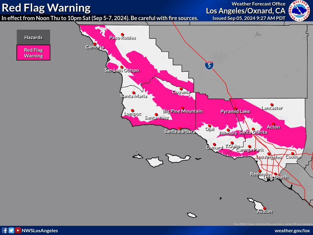
[Update: Thu., Sept. 5, 2024, 2 p.m.] A Red Flag Warning for high fire dangers was called for the south Santa Barbara coastal region and for interior coastal mountains from San Luis Obispo to Los Angeles counties, by the area National Weather Service office. The warning runs from Thursday noon through Saturday at 10 p.m. for the extreme heat, dryness, and gusting sundowner winds expected Thursday and Friday nights.
Santa Barbara County Fire advised that the weather would contribute to rapid spread and intense behavior should a fire occur. In recent years, wildfires have sparked unexpectedly from chains dragging behind vehicles, sparks from heavy equipment tracks, weed whacker blades, open welding on pipes, hot catalytic converters in high weeds, and kites on electrical wires. Signs of smoke or fire should be called in to 9-1-1 immediately.
Wind coming from inland as opposed to the coast is what is driving up the temperature, said Ryan Kittell, a meteorologist with the NWS Los Angeles office. As well, the hot overnight temperatures are what contribute to a greater chance of heat illnesses, he said.
The heat wave is comprehensive, with areas as varied as Santa Cruz Island and the Cuyama Valley both registering triple digits Thursday afternoon.
[Original Story] “Nothing but heat for the next three days,” the National Weather Service announced on Thursday morning. With the previous night’s temperatures ranging from the 70s and upward — hitting a high of 95 degrees at the Santa Barbara Botanic Garden at midnight — warnings abound for heat and fire weather across California and the southwestern United States.
A mild Sundowner last night poured a dry heat into coastal areas, which might see 90 degrees today. In the valleys, the heat is likely to cross the 100-degree mark. Areas of Los Angeles could reach record temperatures, as much as 115 degrees in the Chatsworth area of the San Fernando Valley, the National Weather Service predicted. Stronger Sundowner winds are expected Thursday and Friday.
Friday is expected to be the hottest day of the week, warming 2-4 degrees across Southern California, with the exception of the Central Coast. The mild weather that coastal areas have been experiencing this summer — and towering heights of fog — returns on Friday, which is expected to cool down to the high 80s as ocean breezes return and a decreased marine layer.
The forecast currently sees 3-6 degrees of cooling beginning Sunday, but the possibility exists that air flow from interior areas of California could raise temperatures during the mornings and afternoons.
Excessive heat and fire advisories for inland areas go through Saturday night. For coastal areas, the heat advisory ends a day earlier, but the fire weather watch goes to late Saturday.
The advisories warn of heat-related illness, especially in the very young and the very old, as well as those without air conditioning or engaging in outdoor activities. Stay cool, hydrated, in the shade and out of the sun, and check on friends and family, the NWS advises.
Symptoms of heat illness range from cramps and nausea to dizziness and a weak pulse. Heat stroke can be serious, County Public Health stated, often seen with a body temperature of 104 or above and unusually dry skin. Call 9-1-1 if heat stroke is suspected.
Cooling centers in the county include the libraries and the Cuyama Valley Family Resource Center (4689 Hwy. 166). As well, stores, movie theaters, and air-conditioned vehicles can provide relief. More information is available at ReadySBC.org.
Related Posts


Premier Events

Thu, Sep 19
5:00 PM
Santa Barbara
Artist Reception with Mark Russell Jones

Sun, Sep 15
4:00 PM
Santa Barbara
Green Film Series: Doctrine of Recovery

Sun, Sep 15
5:00 PM
Santa Barbara
Memories: ‘An Evening with Barbra”

Sun, Sep 15
5:00 PM
Buellton
Hitching Post – “SIDEWAYS” 20th Anniversary Dinner

Sun, Sep 15
6:00 PM
Santa Barbara
Join a Social Dance with the Corwin & Grace band

Wed, Sep 18
5:30 PM
Santa Barbara
S.B. Independent District 3 City Council Forum / los candidatos al Concejo Municipal de Westside

Sat, Sep 21
8:30 AM
Santa Barbara
Saying Goodbye and Honoring the Trees at Downtown Farmers Market Location on Cota St.

Sat, Sep 21
9:00 AM
Santa Barbara
Coastal Cleanup Day Santa Barbara County

Mon, Sep 23
5:30 PM
Santa Barbara
S.B. Independent District 1 City Council Forum / los candidatos al Concejo Municipal de Eastside

Wed, Oct 02
12:00 PM
Santa Barbara
“Project Fiesta!” Celebrates 100 Years of Fiesta

Wed, Oct 09
5:30 PM
Santa Barbara
Sewing and Mending Club
Thu, Sep 19 5:00 PM
Santa Barbara
Artist Reception with Mark Russell Jones
Sun, Sep 15 4:00 PM
Santa Barbara
Green Film Series: Doctrine of Recovery
Sun, Sep 15 5:00 PM
Santa Barbara
Memories: ‘An Evening with Barbra”
Sun, Sep 15 5:00 PM
Buellton
Hitching Post – “SIDEWAYS” 20th Anniversary Dinner
Sun, Sep 15 6:00 PM
Santa Barbara
Join a Social Dance with the Corwin & Grace band
Wed, Sep 18 5:30 PM
Santa Barbara
S.B. Independent District 3 City Council Forum / los candidatos al Concejo Municipal de Westside
Sat, Sep 21 8:30 AM
Santa Barbara
Saying Goodbye and Honoring the Trees at Downtown Farmers Market Location on Cota St.
Sat, Sep 21 9:00 AM
Santa Barbara
Coastal Cleanup Day Santa Barbara County
Mon, Sep 23 5:30 PM
Santa Barbara
S.B. Independent District 1 City Council Forum / los candidatos al Concejo Municipal de Eastside
Wed, Oct 02 12:00 PM
Santa Barbara
“Project Fiesta!” Celebrates 100 Years of Fiesta
Wed, Oct 09 5:30 PM
Santa Barbara