
Hugging the Big Sur Coast
Paddling and Kayaking the Rugged Coast Is Challenging but Enticing Adventure

It was raining so hard; we could only see just beyond the shoreline. The surf was big, but the pelting rain and southeast winds prevented us from determining the true swell conditions while paddling the rugged Big Sur Coast.
Still, we had to launch. We were somewhere just south of Andrew Molera State Beach, me in my kayak and former U.S. National rowing team members Patrick O’Hea and Will Miller paddling stand-up paddleboards. The tide was surging in, and there wasn’t much depth to the beach. We were quickly running out of real estate.
When we launched off that nameless beach, the sideways rain, low-hanging fog, and storm clouds created a gray, horizonless expanse within the tempest. We were winging it. The small pocket cove had a tidal surge sweeping up onto the rocks, reverberating back toward our right flanks, so we had waves to contend with from three directions. Most waves pounded in front of us, but the bigger waves produced steep foam balls that gathered momentum, careening off eroding bluffs and back toward our blind side.
I helped O’Hea and Miller launch one at a time without a hitch, but now it was my turn. They paddled through the heaving shore break almost flawlessly. I wasn’t so lucky and mistimed my launch. After jumping into my kayak, I punched through the first wave, but the second wave was bigger and already cresting. Before I knew it, I was surfing backward on a six-foot wave, as water was drawn off the gritty shoreline. When my stern pounded into the sand, I instinctively curled up into a ball, while being catapulted. Bracing for impact, I felt the back of my head graze the shifting shoreline, as a total yard sale ensued.
Miraculously, I came out of it unscathed, minus all the gritty wet sand that found its way between me and my wetsuit. Still, there was no damage to me or my kayak. Other than scrambling for scattered camera gear, spare paddle, and a water bottle, I was already strategizing my next attempt.
While I struggled to launch, I lost sight of Miller and O’Hea, the weather not allowing it. I told them to try keeping within the mouth of the cove. At that point, I just had to get off that beach. And I did, punching through three large waves, and better yet, I found Miller and O’Hea standing tall, pelted by rain beyond the breaking surf.

Patrick O’hea paddles the Big Sur Coast | Photo: Chuck Graham 
Dwarf Redwoods along the Big Sur Coast | Photo: Chuck Graham 
Former U.S. National rowing team members Patrick O’hea and Will Miller paddling The Big Sur Coast | Photo: Chuck Graham 
Sea lions playing along the Big Sur Coast | Photo: Chuck Graham 
Paddling The Big Sur Coast | Photo: Chuck Graham
Big Sur Beginnings
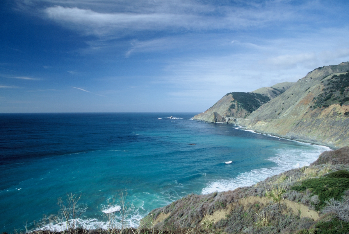
Since Pacific Coast Highway 1 (PCH) opened in 1937, the 75-mile stretch of winding Big Sur coastline has closed 55 times due to landslides. In 2022-23 alone, there were rapid fire closures due to back-to-back wet winters involving multiple slides. Since January 2023, it’s been impossible to drive end to end, north from the Piedras Blancas Lighthouse and south of Carmel. Of the 656 miles of California coastline, the Big Sur coast is arguably some of its most breathtaking. When the road is passable, Big Sur receives more visitation than Yosemite National Park.
Every time I’ve driven the weaving route in the past, my curiosity overflowed with visions of living remotely in coastal California. Because of its daunting coastal topography and strict land use regulations, the Big Sur coast is sparsely populated. Roughly 2,000 people eke out some kind of life along its weather-beaten shores, on the edge of lofty cliffs, and its chaparral-choked Santa Lucia coastal mountain range.
So, it took a paddling trip to soothe my curiosity, hopefully revealing how remote and Mordor-like those massively sheer cliffs truly were. There were plenty of precarious examples of just how far people were willing to go to seek out solitude. A couple of dilapidated dwellings appeared as if they required BASE jump training or wearing a parachute 24/7. Some dwellings were literally clinging to cliff faces, sagging toward boulder-strewn shorelines. Several times, I asked myself, “How does one sleep in those conditions?”
With a combination of steep scree slopes and crumbly rock, Big Sur is always susceptible to shifting earth. Also, increased wildfires don’t help the mountainous topography, and burns followed by wet winters only enhance erosion. Between 2016 and 2023, Caltrans spent $315 million in emergency work shoring up the Big Sur region.
With Highway 1 being closed going on two years, the ragged coast still beckoned. Most visitors that travel its curvy coast don’t get the chance to see the stunning perspective from sea level. It was impressive.


After the Storm
It’s amazing what blue skies; puffy, white clouds; and sunshine can do to brighten the outlook of an excursion. The three of us ditched our wetsuits, trading them for baggies, hats, sunglasses, and sunscreen. We were gliding down the Big Sur coast.
Still, there were other difficult landings in huge surf, moments of reflection beneath starry nights, and cool wildlife encounters, followed by challenging launches all well below PCH.
From above, Big Sur has always appeared intimidating. While paddling, the three of us agreed, its coastline was no joke.
During our last day on the water, the coastal mountains trailed eastward, as steady northwest winds propelled us toward the windswept beach just north of the Piedras Blancas Lighthouse. Another messy landing awaited, but so did solid ground. However, nothing came easy while paddling the Big Sur coast.
Related Posts


Premier Events

Wed, Dec 25
6:00 PM
Santa Barbara
FREE Contra Dance X-mas Day💃Corwin & Grace band6-9

Tue, Dec 24
2:00 PM
Santa Barbara
Brass Bear Christmas Eve Buffet

Tue, Dec 24
5:00 PM
Santa Barbara
Christmas Eve at the USSB

Wed, Dec 25
5:30 PM
Santa Barbara
Christmas Dinner at El Encanto

Fri, Dec 27
6:00 PM
Solvang
New Year Disco Ball Paint & Sip

Fri, Dec 27
9:00 PM
Santa Barbara
Film Screening: “Indiana Jones and The Last Crusade”

Sat, Dec 28
7:00 PM
Lompoc
Rosie Flores & Grey DeLisle + Special Guests LIVE

Sat, Dec 28
7:00 PM
Carpinteria
Family Comedy Night at The Alcazar

Sat, Dec 28
7:00 PM
Santa Barbara
The Temptations at Casa De La Raza
Sat, Dec 28
9:00 PM
Santa Barbara
Film Screening: “Indiana Jones and The Last Crusade”

Tue, Dec 31
5:00 PM
Santa Barbara
New Year’s Eve Dinner
Wed, Dec 25 6:00 PM
Santa Barbara
FREE Contra Dance X-mas Day💃Corwin & Grace band6-9
Tue, Dec 24 2:00 PM
Santa Barbara
Brass Bear Christmas Eve Buffet
Tue, Dec 24 5:00 PM
Santa Barbara
Christmas Eve at the USSB
Wed, Dec 25 5:30 PM
Santa Barbara
Christmas Dinner at El Encanto
Fri, Dec 27 6:00 PM
Solvang
New Year Disco Ball Paint & Sip
Fri, Dec 27 9:00 PM
Santa Barbara
Film Screening: “Indiana Jones and The Last Crusade”
Sat, Dec 28 7:00 PM
Lompoc
Rosie Flores & Grey DeLisle + Special Guests LIVE
Sat, Dec 28 7:00 PM
Carpinteria
Family Comedy Night at The Alcazar
Sat, Dec 28 7:00 PM
Santa Barbara
The Temptations at Casa De La Raza
Sat, Dec 28 9:00 PM
Santa Barbara
Film Screening: “Indiana Jones and The Last Crusade”
Tue, Dec 31 5:00 PM
Santa Barbara