
More Lake Fire Evacuations Canceled Wednesday as Containment Reaches 42 Percent
Areas South of Fire Perimeter No Longer Under Evacuation Order; Fire at 38,663 Acres

Areas South of Fire Perimeter No Longer Under Evacuation Order; Fire at 38,663 Acres
[Updated: Thu., July 18, 12:20 p.m.]
A few more evacuation orders have been canceled on the southern side of the Lake Fire in Northern Santa Barbara County as crews continue to battle the blaze, which is now reported by Cal Fire at 63 percent containment and 38,663 acres.
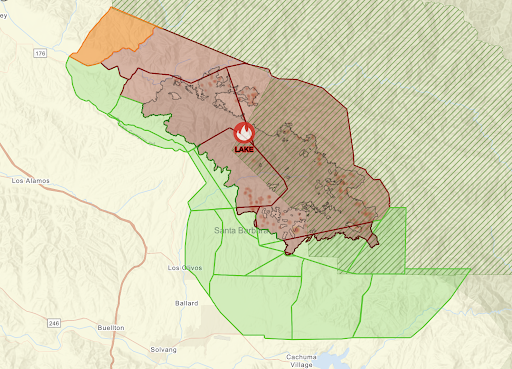
County emergency officials had previously canceled evacuation orders and warnings in several areas to the south and southwest of the fire line, and on Wednesday afternoon, evacuation orders and a warning were lifted for areas directly southeast of the fire perimeter near Goat Rock and McKinley Mountain.
Evacuation orders remain in place in the areas directly adjacent to the fire to the north and northwest, including: between the western fire perimeter and the Los Padres National Forest closure area; east of La Brea Creek and south of the Los Padres National Forest boundary; and north of the Sisquoc River.
One evacuation warning remains in place in the area east of Kelly Canyon, north of Sisquoc River, west of La Brea Creek, and south of the Los Padres National Forest.
Officials urge residents to exercise caution in returning home, and remain vigilant if they are still living within the evacuation warning area. Residents can check the 2024 Lake Fire Incident Map to see if their specific address is under an evacuation order or evacuation warning.
All roads, trails, and recreational areas within the Los Padres National Forest Fire Area Closure remain closed during this time.
For more information and live updates, check ReadySBC.org.


Please note this login is to submit events or press releases. Use this page here to login for your Independent subscription
Not a member? Sign up here.


You must be logged in to post a comment.