
This article was underwritten in part by the Mickey Flacks Journalism Fund for Social Justice, a proud, innovative supporter of local news. To make a contribution go to sbcan.org/journalism_fund.
[Update: Mon., July 15, 2024, 8:30 p.m.] The Santa Barbara County Sheriff’s office canceled several evacuation orders and warnings on Monday evening while maintaining those in areas still unsafe to the public.
• Evacuation orders remain in place for areas currently unsafe for the public to return to. These are remote areas, some without identifiable landmarks. See map for details.
• Evacuation warnings remain in place for the area east of Kelly Canyon, north of Sisquoc River, west of La Brea Creek and Forest Route 10N06, and south of the Los Padres National Forest, as well as the area starting at the south end of Cachuma Creek, northeast of Santa Cruz Creek to Santa Cruz Peak, west through Grand Spring, and to the northern part of Cachuma Creek.
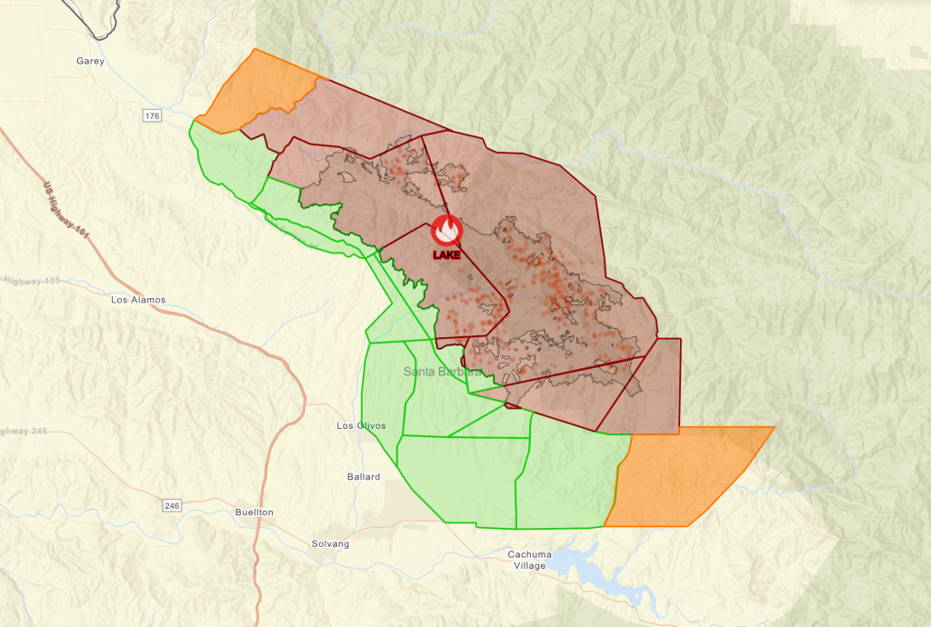
Residents can utilize the Lake Fire Incident Map to type in their address to see if their property remains under an evacuation order or evacuation warning area.
The Sheriff’s Office advises all residents in evacuation warning areas to remain vigilant and those driving back home to exercise caution as public safety and utility vehicles continue to conduct operations in the area.
Residents can find information about ash cleanup and more by visiting the ReadySBC Recovery section. Printed copies of information for those returning home can be picked up at the Solvang Sheriff Station at 1745 Mission Drive, which is open Monday-Friday, 8 a.m.-5 p.m (closed noon-1 p.m.).
Evacuation warning and order areas may continue to change while Lake Fire conditions evolve. Stay connected to official sources to keep informed, including ReadySBC.org.
[Original Story] Of all the parties involved in the Lake Fire — first responders, homeowners, elected officials, etc. — hunters aren’t a group that immediately comes to mind. But archers, whose official season began on July 13, are being warned that fire crews will likely impede on their hunting grounds, working outside of the fire area to build contingency lines. Early-season archers might have to delay their first hunt – but not for long.
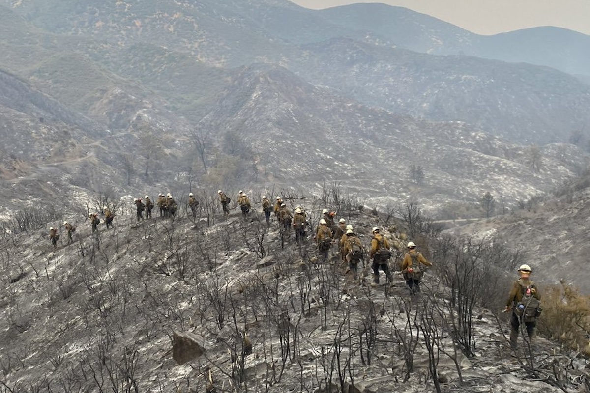
The Lake Fire is now expected to be fully contained by July 31 according to Santa Barbara County Fire spokesperson Scott Safechuck. The fire has burned more than 38,000 acres and is currently 38 percent contained — up from Sunday morning’s 19 percent — with the South Zone experiencing zero growth on July 14. Crews have now contained a solid line running from the Sisquoc River down to Happy Canyon and are continuing to “mop up” the southern perimeter. As of Monday afternoon, 72 percent of the South Zone was contained.
In the North Zone, firefighters are entering remote areas of Zaca Ridge — the middle of the fire area — via helicopter to increase containment lines from the inside. The northern portions of the fire are the number one priority, said Cal Fire’s Clint Swensen, especially with winds picking up throughout the day. The North Zone was 5 percent contained on Monday.
The crew count is declining — now down to 3,427 — as fires in other parts of the state pick up speed and priority. Much of the Cal Fire crew is getting reassigned to Kern County to help tackle the White Fire and Hurricane Fire.
Temperatures on July 15 ranged from the high 80s to the low 90s — still hot on the fire line, but a welcome change from last week’s triple-digit temps. Increased humidity and cooler temperatures have helped reduce fire activity over the past couple of days, but there will be “gradual warming and drying through the week,” said Cal Fire’s Kyle Ferris.
As evacuation orders and warnings have loosened, people are beginning to return to their homes, almost all of which were left undamaged. Santa Barbara County Sheriff’s Deputies will be passing out N-95 masks and post-fire safety pamphlets to residents at Highway 154 and Roblar Avenue.
The Air Quality Alert was reduced to an Air Quality Watch for the Santa Ynez Valley and other areas near the Lake Fire in light of recent good to moderate air conditions. Smoke production is expected to increase this week as temperatures rise and the fire becomes more active, according to Seth Morphis, an on-site Air Resource Advisor who will provide consistent Smoke Outlooks in the area. For the most recent updates, including air quality information and evacuation maps, go to ReadySBC.org.


You must be logged in to post a comment.