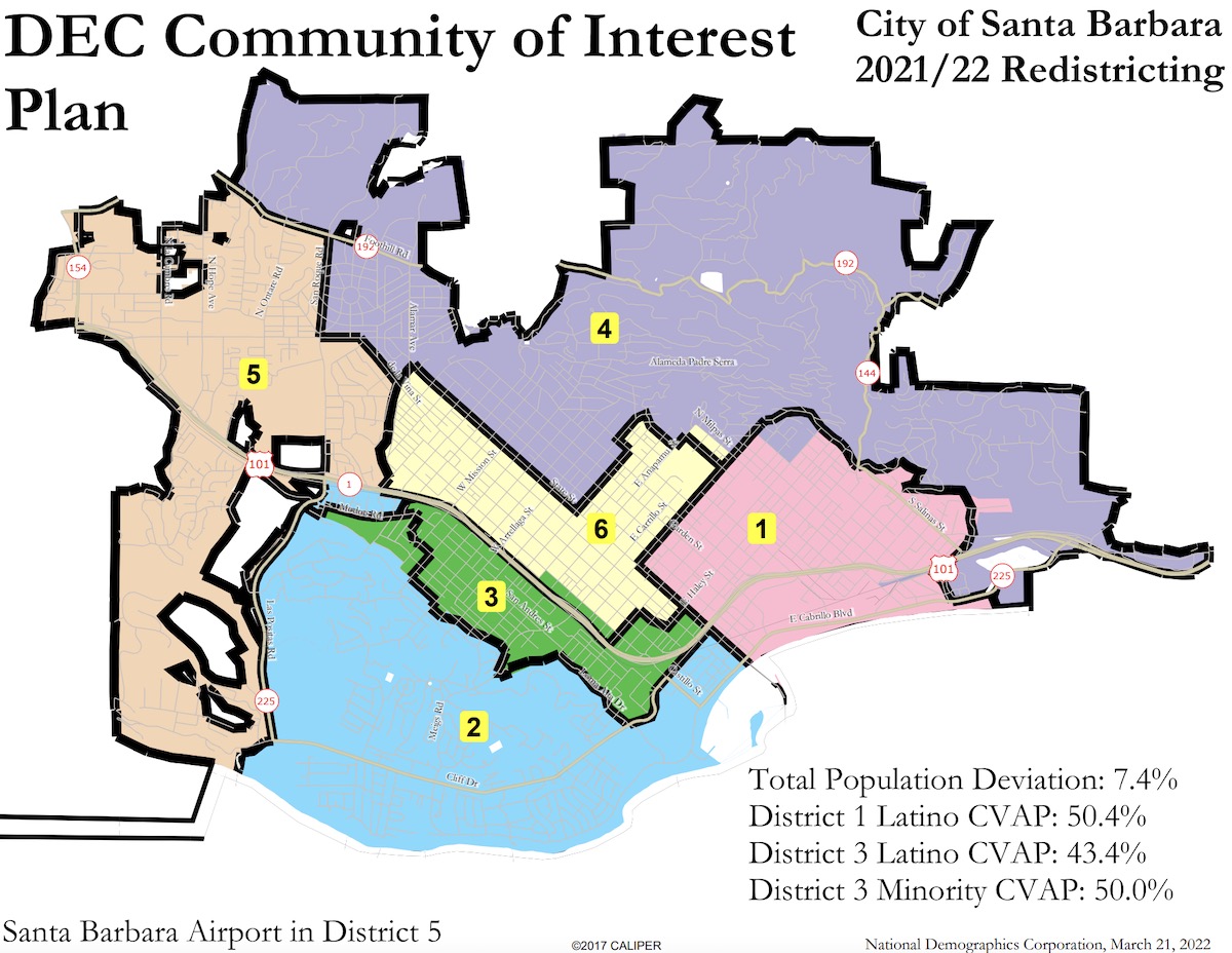
Following over 10 months of meetings, public input, and deliberation, the Independent Redistricting Commission has chosen an updated district election map for the City of Santa Barbara, drawn in collaboration between the city’s consultant and the District Elections Committee to submit to the City Council for approval.
The decision came in last week’s final meeting of the commission, which is made up of three retired judges, all from neighboring counties. Judge Melinda Johnson, from Ventura County, chaired the commission and was joined by former Los Angeles judges Abraham Khan and Elizabeth Allen White. The three judges were chosen to ensure a map that complied with state and federal law and was not driven by political reasoning.
“We have no vested interest in your political life,” Johnson said. “The downside, of course, is we don’t know this beautiful city the way you do.”
During public comment, some in the community wondered why the city would want to change districts, but since the demographics changed according to the latest census numbers, the old map would have put the city in hot water legally without two “majority-minority districts,” districts in which the majority of constituents are racial or ethnic minorities. So the commissioners were tasked to submit a map that would maintain two voting districts with at least a 50 percent minority voting population while also working with input from the community to keep the districts’ consistent to their own unique flavor.
“We now understand the importance of the Westside Community Center and the difference between the 101 bordering a district and running through a district,” Johnson said. Through the process, she added, the commissioners learned the importance of schools and neighborhood associations, as well as the history of districting in the city, to avoid having what she called a map that looked like “a salamander wiggling its way through it.”
Sign up for Indy Today to receive fresh news from Independent.com, in your inbox, every morning.
Consultant Daniel Phillips, from the National Demographic Corporation, worked in collaboration with the District Elections Committee and, using comments from the commission and the public, drew the final draft of the map, called the “Communities of Interest” map. Phillips said the draft is “even more of a minimal change plan” than the previous maps, and took into account the input from city councilmembers, neighborhood associations, and legal council.
The changes mostly affected the Eastside and Westside districts — the two with the highest Latino voting populations — and the boundaries are otherwise consistent with the current map.
The Westside’s District 3 will now reach across the freeway, for a six-block stretch along Castillo which includes the Westside Neighborhood Clinic, formerly in downtown’s District 6. With the new plan, all six districts would have a piece of State Street, and both the Eastside and Westside districts would meet the minimum 50 percent minority voting age population.
The biggest trade-off, from the comments in the meeting, was the decision to redraw a northeastern corner formerly in the Eastside’s District 1 in order to keep East Beach in the same district. The trade-off, Phillips explained, would keep the “majority-minority” population intact.
“I think you have pulled off the impossible,” said City Councilmember Kristen Sneddon — who represents outer State Street, San Roque, and parts of the Riviera in District 4 — during the meeting. “You’ve listened to the community, you’ve made adjustments at every meeting, you’ve kept neighborhoods together.”
Fellow Councilmember Oscar Gutierrez, who represents the Westside’s District 3, also spoke in support of the “Communities of Interest” map chosen by the commission.
The City Council is expected to vote on final approval of the map on April 12.
Support the Santa Barbara Independent through a long-term or a single contribution.


