
When in Doubt, Paddle South
A Perilous Journey by Kayak to Santa Barbara Island

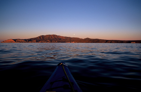
In the black of night, I swore I saw a flicker of light where the night sky meets the dark sea. From my kayak, the horizon naturally undulated in the uneven wind waves somewhere along the Pilgrim Banks between Anacapa and Santa Barbara Islands. Were my eyes playing tricks on me? All we could do was paddle on into the night hoping to touchdown on the smallest of California’s Channel Islands.
Hours earlier we put in under the bright beam of a full autumn moon, no headlamp needed at shimmering Scorpion Anchorage. The moderate down-coast current easily propelled us beyond the tip of San Pedro Point and the southeast end of Santa Cruz Island. Before we knew it, we were enjoying the sunrise glowing behind West Anacapa Island and the Santa Monica Mountains, and the full moon setting beyond Montanon Ridge on Santa Cruz. All that lay before us was our pelagic pilgrimage to Santa Barbara Island.
When long-time kayak guide Tony Chapman approached me last summer on Santa Cruz Island about paddling to Santa Barbara Island, I didn’t hesitate. “When?” was all I wanted to know.
October was an obvious choice. Mild paddling conditions generally prevail, and hopefully we’d have enough daylight to reach our destination. We also had to sneak through the live-fire zone of the Pacific Missile Test Range, which prevented us from leaving much earlier than we wanted. From Scorpion Anchorage, it would be about 44 miles to the lonely, craggy isle, no solid ground between islands to stretch stiff legs and let the blood flow back down to our feet. If things went smoothly, we estimated paddling to Santa Barbara Island to take around 12 hours.
The Passage
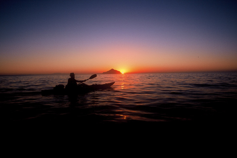
Paddling between the islands in the Anacapa Passage was serene as pink and orange hues blended across the rugged Santa Monica Mountains like a watercolor painting. While on our starboard side a stunning deep purple ascended toward the full moon setting above Montanon Ridge. As we left the islands in our wake a small pod of Risso’s dolphins spouted eastward, the male’s white scarring that comes with maturity evident on their broad backs. Beyond the marine mammals, only calm, glassy waters stretched to the horizon. How long that would last played on my mind with each passing hour.
After more than seven hours of paddling and despite the thick haze, I could still see Santa Cruz’s Yellow Banks over my right shoulder. I was growing worried that we may have miscalculated our compass heading. Chapman had us at 160, but my gut was telling me we were aimed too high. We were now in the navy’s live-fire zone. Maneuvers had ended at 8 a.m., but we could still see a vessel to the west. Even closer was a tugboat moving just a little faster than we were southwest us.
“Let’s go ask the tugboat captain exactly where we are,” I suggested to Chapman.
Chapman hailed the captain on his radio, and my worst fears were confirmed. We were paddling in the wrong direction.
“You need to be heading at 127,” said the captain, referring to our compass heading. “You have 26 miles to go.”
Towing the Line
It was already 1:30 p.m. I knew right away that in the coming hours we would be paddling at some length in the dark. My heart sank a bit, but I wanted to get moving and ramp up the pace. For a couple of hours I noticed Chapman wasn’t paddling with the same steadiness he displayed earlier in the day. I was concerned. I was paddling harder, but it wasn’t doing either of us any good with me paddling ahead then waiting for Chapman to catch up. Finally, at 5 p.m., I suggested to Chapman that I put him on tow. That wasn’t easy for me to do. The 75-year-old Chapman is an accomplished kayaker and has been a lead guide at the national park for almost 30 years. He’s also competed in a number of kayaking races. I was reluctant to ask.
“How do you feel about me putting you on tow?” I asked.
“Well, if you think you should,” he replied.
“I definitely think I should.”
It wasn’t so much that I was paddling faster; with night approaching, it made more sense to me to bring our kayaks together to minimize some risk.
Once Chapman tied his bowline to my stern I paddled at my pace, and with a moderate 10- to 15-knot northwest tailwind, it felt like we were moving at a better clip. However, we couldn’t see the mainland anymore, and with the sun sinking quickly in the west, I found myself fending off worst-case scenarios in my head.
At 6 p.m., I suggested we get into our warm gear. My wetsuit was on up to my waist. All I needed to do was pull it up and over my head. Chapman had some wetsuit pants, and he wrestled into those. Next came on the spray jackets and beanies. Chapman wore his headlamp to track our compass heading. We quickly ate and drank and pressed on.
Visions of missing Santa Barbara Island were still weighing heavy on my tired shoulders. Were we really going to have to paddle east and push for the mainland? If that was the alternative, the entire trip would be a total of at least 80 miles. I wasn’t looking forward to that — or paddling in the fog through the shipping lanes. But then the moon appeared glowing in the east, lifting my spirits as it rose quickly. Also burning bright was a southerly star high in the sky.
“If you follow that bright star,” hollered Chapman in the dark, choppy seas, “it’s in line with our heading.”
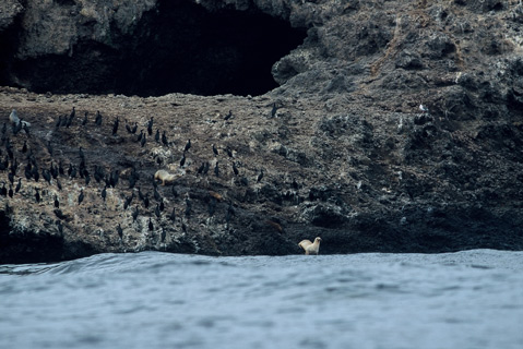
So with the moon to my east and that bright star to the south, I was feeling more confident with our heading. As the night wore on, the seabirds became curious about the two blue kayaks rocking in the deep cobalt seas. Migratory black-vented and sooty shearwaters flew directly at us, and then banked away at the last second. On several occasions, solitary ashy storm petrels swooped off my bow and then vanished in the unsettling seas.
We knew that after 6 p.m. the folks at the national park would begin wondering where we were. We told the ranger on Santa Cruz the night before we left that we expected to reach Santa Barbara Island by then. By 8 p.m., we heard over the radio the Santa Cruz ranger and the researchers on Santa Barbara Island discussing our whereabouts. Sensing some mild anxiety in their transmissions, Chapman tried several times to contact them, but we weren’t close enough to the island.
It was now 8:30 p.m., and mentally, I was still fending off perpetual what-ifs. Rapidly fluctuating between the positives and the negatives, I put a cheery spin on paddling in the dark. Ironically the visibility was better than at daytime when all I could see was haze. I kept telling myself the full moon and that bright star were what we needed. But then I would feel discouraged because I wasn’t seeing anything resembling the triangular shape of Santa Barbara Island.
Suddenly, I felt Chapman’s kayak go slack behind me. I thought his line had snapped, but it simply came untied. We quickly came together, and Chapman retied his bowline to my stern. However, Chapman dropped his paddle in the dark waters at the same moment, and the black shaft with the dark red blades instantly disappeared in the dark, capping seas. When he told me, my heart sank for a millisecond, and then I turned to the south and saw what looked like Sutil Island, the smaller, yet ominous isle about 1/8 of a mile southwest of Santa Barbara Island.
Until then, my eyes had been playing tricks on me. I thought I was seeing lights flashing on the horizon because I knew Santa Barbara Island had an automated light off Arch Point on the north end of the windswept island. Whether it was operating I didn’t know. There was nothing wrong with hoping. I asked Chapman if he could confirm my sighting.
“Are you seeing Sutil Island?” I yelled in the wind.
He couldn’t tell either because most of Santa Barbara Island was cloaked in fog except the northern tip. That’s when I saw the automated light flashing on Arch Point. It was a glorious site; shafts of moonlight striking down on the wave-battered isle swept in a swirl of dense, dewy overcast and the beacon going off on the north end of the islet. We went from complete despair to utter elation in a matter of seconds.
It was difficult to tell in the dark, but it appeared that we might be about seven miles northwest of the island; now we had points of reference to work with. First we had to reach Webster Point, and then paddle past guano-covered Shag Rock and Arch Point. It took me another 2.5 hours to reach the Landing Cove. Without a paddle for Chapman, we had no way of controlling his kayak. He just had to sit back and enjoy an unstable ride while I wrestled with the choppy seas, thick kelp, and current on the north side of the isle.
On our approach, Chapman tried contacting the researchers on Santa Barbara Island to no avail, but a boat somewhere between the island and us relayed our message to the researchers on the island as we approached Shag Rock.
“Rounding third!” I hollered in relief while paddling beneath the massive archway of Arch Point.
Gratefully, the researchers were waiting for us as we came alongside the ladder connected to the dock. They helped hoist our kayaks and gear up onto the top deck, and instead of having to pitch tents at midnight, we crashed inside the ranger’s quarters. Needless to say, we were both a little stiff and fatigued, but standing on solid ground was something to behold even though it felt like the dock was rocking and rolling beneath our feet.
A paddling trip that began in the dark guided by a full moon ended as it began 17 hours later on an ominous speck of an island, where two weary kayakers were grateful it was there.


