Search & Rescue’s Got Your Back
How I Got Lost in the Woods and Encountered the Guardians of the Wilderness

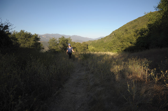
As dusk descended, I was walking happily along the trail from Cottam Camp to Camuesa Road, to meet up with a friend who was already out there with everything we needed. I was taking advantage of the evening hours of a hot summer day to revel in the profoundly slow beauty of the Los Padres National Forest.
I’d set out at 6:15 p.m., and figured I would make it to Camuesa around nightfall. The sun was scheduled to set at 8:15 p.m., and I had laughingly instructed my friend not to start “looking for my half-eaten remains” until 10, so I wasn’t sweating the deadline. This wasn’t the trail I’d told my friend I was taking, up Blue Canyon. I’d lost that early on as it seemed to lead directly through tangles of poison oak and down into foot-deep creek pools with no obvious place where it continued after that. Instead, I’d opted to follow the arrow pointing downstream, along a well-marked path that I knew would lead to a Santa Ynez River crossing at Cottam Camp. I’d been that far before, and from there, I’d heard, it was easy to reach Camuesa Road near Pendola.
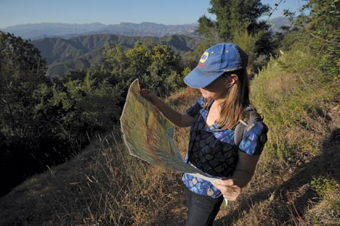
After Cottam, the path didn’t stay incredibly well-marked, but I’d found it again each time it crossed a stream or spread onto open chaparral. I was feeling pretty smug when, with one last, slim metal signpost — painted white and reading simply “TRAIL” — it abruptly dumped me out onto a wide boggy section of what I guessed was probably the bed of the Santa Ynez River. Though I wasn’t positive. Silly goose, not to have stuck Ray Ford’s beautiful, easy-to-use, topographic Front Country Trail Map into my backpack.
I found no complementary trail sign on the opposite bank, which was about 50 brush-and-ravine filled yards away. I did find a big fat rattler. We both ran screaming away from each other.
I scrambled back into the riverbed and proceeded upstream until I could find no way forward except through steep-sided, thigh-deep water passages. That couldn’t possibly be the right way to go. By now, it was dark enough that I had to turn on my little flashlight.
The last cell phone service I’d had was at the trailhead of the Blue Canyon connector, which was near Romero Saddle, where I’d parked. My greatest fear, when I realized that I would not arrive at my destination by 10 p.m., was that Santa Barbara County Search & Rescue would be called. Heroic volunteers would be rousted from their beds, I would be airlifted out, and a press release would announce my waste of taxpayer money and that of generous donors. I would be humiliated and stripped of my Adventure Pass (if I’d had one).
I decided to trek back to my car, hopeful that I could make it by midnight. I lost the trail. I whined for help. I found the trail again, I thought, and then found myself magically transported back to the riverbed, following the footprints I’d left a half-hour earlier. It was like something out of The Blair Witch Project. Shocked as I was at first to be headed in that direction, whatever it was, I felt lucky to be on now-familiar ground. After mistakenly approaching some brilliant yucca blooms, I finally located my now-beloved “TRAIL” sign, with its luminescent white paint, and sat down to wait for morning.
I resolved to not panic, imagining a little plastic bracelet around my wrist bearing the legend WWRHD: What Would a Responsible Hiker Do? But then I started signaling passing jets with my flashlight, using the old Morse Code distress signal: short-short-short, long-long-long, short-short-short. If Search & Rescue was looking for me, they might as well know where I was. I finally decided that this was not a responsible thing to do, because it was apparently futile and it was using up precious battery charge. I had not brought extra batteries. And anyway, this was not an emergency.
Still, it was with great relief that I finally saw two men coming down a trail carrying torch lights. I called out to them and shined my flashlight on treetops for several minutes until I realized they were merely stars twinkling on the horizon. I was very alone.
I knew I had to stay awake in case people were looking for me. I took everything out of my backpack so I could use it as a mat, and placed a bottle of wine near my right hand, so I could use it as a weapon. I turned off my cell phone to save the charge. I had plenty of water, and four nectarines, which I placed several yards away so that a bear would not have to go through me to get to them.
I located the North Star, and kept an eye out for the Search & Rescue planes I hoped would not come. I thought of myself as a shepherd, made up new constellations, and sang “A Horse with No Name,” until I stopped because I thought I sounded like a bird in distress and might attract a cougar, but then said to heck with it and resumed. I lay down a few times but inevitably leapt up to shout at bushes from which the sounds of human-eating predators were emanating.
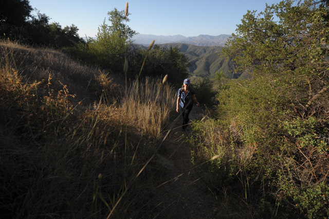
Thankfully, the night was unbelievably gorgeous and warm, but I’ve never been so thrilled to see the sunrise, which let me start moving again. I promptly wasted two hours trying to push ahead to Camuesa, then turned around to go back to my car and couldn’t find the trail sign. I decided to thrash down the riverbed to Cottam Camp but found the way impassable. Once I almost cried, upon finding my path blocked for the umpteenth time, but stopped because I didn’t want to waste salt and water. I turned around again with the intention of continuing all the way upriver, to wherever, in the riverbed. I was walking leisurely, beginning to downgrade my goals to not spending a second night lost in the forest, when I happened again upon the trail sign.
When I finally made it back to Cottam Camp, I used rocks to leave a note on the picnic table, configuring them into my initials and an arrow pointing the direction I was going. That, it turned out, was a good thing to do: A friend out looking for me found it and informed Search & Rescue via satellite phone. It might have been even better if I’d left a time. I would also later be congratulated for alerting friends to my route, but scolded for not sticking to that route; my most fundamental error, though, was setting off on an unfamiliar wilderness trail so soon before nightfall.
By 10:30 a.m., I was two-thirds of the way to the top of the mile-high Blue Canyon connector where I’d started, when my phone became operational. I was on the line to 9-1-1, explaining that I was okay, when I heard the helicopter. The dispatcher said they were trying to get a reading on my location, and I needed to stay on the line. Then I sat down, which was enough to cut the fragile connection. Partly from exhaustion, partly from pride, and partly because I didn’t know whether I’d be charged for a rescue, I didn’t call back but kept climbing up the hill — very hot and very slow. Fortunately, I had brought plenty of water so was neither dehydrated nor risking a giardia infection by drinking wild water. (By the way, if you breathe in through your nose, instead of your mouth? The air coming in is way cooler.)
When I got to the top, there were four smiling people saying “Hi, Martha,” handing me ice-cold water, and ushering me into the van with the air conditioning on high. Unless I had died and gone to heaven or was being kidnapped by a cult, this was Santa Barbara County Search & Rescue. They drove me to Romero Saddle, where I saw two or three more vans, an all-terrain vehicle, and a grim-looking Santa Barbara Sheriff’s deputy, who had thought that this was going to be “a case for the coroner” and was treating the trailhead as a crime scene, complete with caution tape on my car.
The volunteers sat with me in the van until I was ready to go, offering me a granola bar and being exceedingly gracious. I found out they don’t charge for rescues, but that sometimes the rescued send in donations ranging from $15-$600. I apologized for ruining an otherwise perfect Sunday beach day, but they assured me there was nothing they would rather be doing. As I was leaving, the team was determining whether they needed to rescue a dirt biker whose motorcycle had sprung a leak about 10 miles out and who was consequently trudging back, in the blazing sun and his motorcycle boots, and possibly in danger of dehydration.
What I came to appreciate was that Search & Rescue goes way beyond service to strayed or injured individuals. They are a big part of preserving the wilderness itself, by enabling people to go out into it and appreciate it — without road signs, cell towers, or convenience stores. If you want to get close to nature, they’re the ones who’ve got your back.