
Channel Islands Adventure
Whale Watching, Nature Hikes, and Kayaking with Truth Aquatics

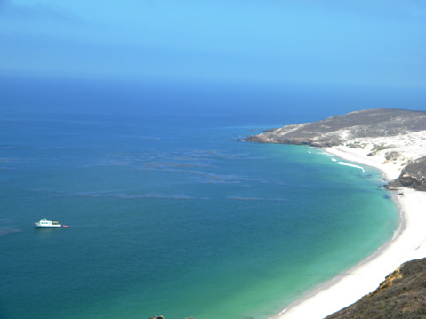
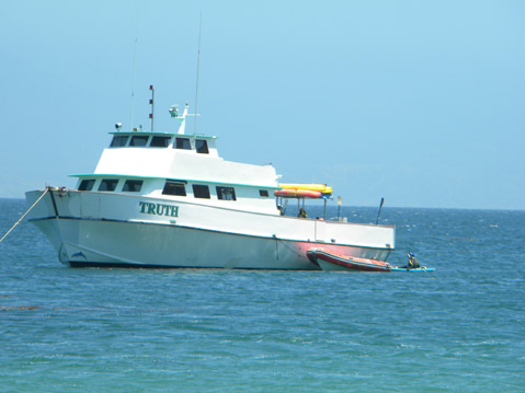
As a recent UCSB graduate, the experience of waking up in a strange location while the world bobs and sways around me was familiar. The sensation of being jolted awake at 7:30 in the morning was not. The ship I was on, Truth from Truth Aquatics, had suddenly killed its engine midway through its Thursday morning journey from Sea Landing in Santa Barbara to the Channel Islands. I stumbled onto the deck to get my bearings, and as soon as I rubbed the sleep out of my eyes a jet of water erupted like a geyser out of the ocean.
“I’m about 90 percent certain that we have some blues here,” announces Graham, our captain. In a few seconds, a few more spouts blast into the air off our port and bow (or left and front for the nautically illiterate). Mammoth bodies breach the surface before lumbering back down into the dark water. In the brief minute it took me to grab shoes and some warmer clothes, blue whales completely surround the boat, which Graham says indicates a feeding session. Everywhere there are streams shooting from blowholes, a massive tail slapping the water, or a circle of calm water among waves known as a whale footprint. For a minute, a school of leaping dolphins joins in, as if guiding our ship through the pod without hitting any of the whales.
The experience proved to be a fitting start to a weekend that everyone would describe to me as “very lucky,” for the rest of my adventures on San Miguel, Santa Rosa, and Santa Cruz islands, were blessed with unbeatable weather, great food, and amazing experiences that revealed the past, present, and future of our beautiful, yet fragile islands.
San Miguel: The Recovered Island
After some hot coffee and breakfast prepared by Dennis, the Truth‘s chef, the 14 of us on board made sack lunches and prepared for a day of hiking on San Miguel, the westernmost island of the chain. Five at a time we piled into a small skiff, and deckhands Alex and Chancey sped us to the beach. After landing, our on-board naturalist, Sebine Faulhaber, led us up a steep and narrow dirt path through brush, black stink bug beetles, and pink and yellow flowers.
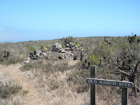
Ian Williams, San Miguel’s ranger, greeted us and took us through an area normally closed to visitors. He stopped at a canyon with wooden beams protruding from the ground and a crumbling adobe wall, and explained it was the site of the latest archeological discovery on the island. Last March, researchers found this to be the location of the first ranch house on the island, built by Samuel Bruce in the 1850s. The beams were the flooring, and the type of wall construction indicated that he used native people for the construction.
The story of the destruction caused by ranchers on the Channel Islands is nothing new- Bruce’s own sheep created the sand dunes that effectively buried his house-but San Miguel has been free of grazers for more than 30 years, giving it the longest recovery of all the islands. Although fencing from sheep corrals can still be seen and there is a noticeable lack of trees due to no fresh water sources, the island that was mostly a sand dune not too long ago is now covered with brush and flowers. Lichen and Spanish moss, which can only thrive in pure air, grow on the branches of bushes, a testament to the quality of air out here. There is San Miguel locoweed, a yellow flower named by ranchers for its abilities to drive livestock crazy when eaten, and some droppings of the Channel Island fox, whose population got to a low of 15 on San Miguel and is now 100-200.
Perhaps the most striking image is the site of the third and final ranch house, built by George Nidever around 1905. The once proud structure exists now as just a pile of rubble with some rusted sinks and toilets overgrown with plants. It’s a humbling reminder of what happens when civilization ends, and a reflection of the success of the ecosystem’s return to balance.
Another favorite activity on these islands is kayaking. The Truth moved down the coast of San Miguel a bit to a section of beaches heavily populated with California sea lions and elephant seals. Donning a wetsuit and life jacket, I got into a kayak for the first time in my life and paddled over to an area where male elephant seals were violently settling a dispute. Curious sea lion pups swam over to check us out, barking playfully. We also explored some caves, and the more advanced paddlers explored around the point of our protected area.
While we hiked all day, the deckhands were busy diving and successfully catching rockfish. While Truth Aquatics prides itself on its meals, Dennis outdid himself with this dinner of barbequed fresh fish, vegetables, pasta, and pineapple upside-down cake. Bottles of wine popped as we ate, drank, and talked the sun down.
Santa Rosa The Rebuilding Island
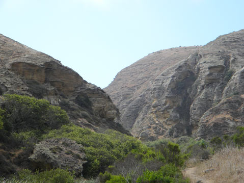
I awoke Friday morning to a relatively empty boat. We’d traveled to Santa Rosa Island and about half of the people were already on a long kayak around the island. I opted for another hike, this time going through Lobo Canyon. Sebine explained that Santa Rosa not only has more soil and fresh water than San Miguel, but natural canyons like Lobo work to protect the flora from grazers resulting in thicker vegetation with oak trees, reeds, and yellow and red flowers.
Poppies abound, but unlike the red and golden ones on the mainland, here they are yellow. While buckwheat on San Miguel was a low, ground-covering bush, on Santa Rosa it is much taller with thicker stalks, and sports a vibrant red color. There are even some prickly pear cacti, with magnificent multi-colored flowers among the thorny green leaves.
Throughout the canyon there are awesome rock formations. My favorite is wave rock, which as the name implies, resembles a closing out hollow wave, and allows for a great opportunity for a picture of riding a mountainous barrel.
With each turn through the windy canyon, the view is somehow more majestic than the last. I felt a bit like William Wordsworth as I stood in front of the sublime beauty of Lobo, and felt I couldn’t possibly take enough pictures to capture it.
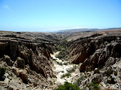
Upon exiting the canyon, we veered onto Smith Highway, a wide dirt road that runs to the top of the Lobo. On the rim, the landscape is desolate, dry, windy, and little life appears to exist apart from a few abandoned horses, the occasional lizard, and endless fields of brown grass. This is the result of farming, and although the sheep, pigs, and cattle have been removed, deer and elk still exist here, that is until their scheduled removal in 2011. Sebine pointed out a massive canyon, whose brown and barren appearance is the result of soil erosion. The Smith Highway runs like a scar across the island, and the fences and gates reminded me of a line from The Doors’ “When The Music’s Over,” when Jim Morrison cries out, “What have they done with our fair sister : they tied her with fences : and dragged her down.”
To be fair, I visited at height of the summer when most of the vegetation has dried out. After the winter rains, the island is much greener and “juicy,” Sebine said. On the way back down the hill toward the beach, signs of beauty spring up again with more of the yellow poppies and the most colorful cactus I have ever seen, evidence that the environment is slowly rebuilding. The hope is that with time, the rest of the island will be covered with the vegetation it was once home to.
Nature isn’t the only one rebuilding on Santa Rosa. A large crane and construction equipment is visible at the coast, where the old pier is being removed to begin construction of a new one. Next to the old ranch house, newer and more eco-friendly buildings are in place to serve the campers who frequent the island.
Santa Cruz: The Civilized Island
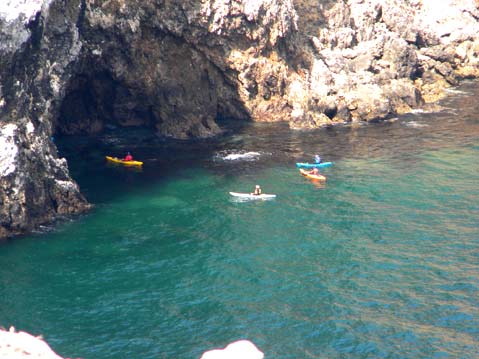
Back on the boat, we immediately departed for Santa Cruz Island in hopes of getting some sunset kayaking through Painted Cave, the world’s longest sea cave. This cave is so large that The Wish is able to fully enter it. After finding a place sheltered from the wind to anchor, I climbed into my kayak to power through a grueling 40-minute paddle against the wind and waves. The result is worth it, as our small vessels and headlamps allow us to explore the rooms in the back of the cave. I see where it gets its name, as the walls are colored blue, yellow, green, and red. In the back, shiny layers of what appears to be pyrite cover the ceiling.
Back on the boat, Dennis once again has an outstanding meal prepared, this one Thanksgiving themed. I’m talking about the works: dark and light turkey, mashed potatoes, sweet potatoes, stuffing, vegetables, and rolls while outstanding eggplant meals were ready for the non-meat eaters.
The next day, the group of kayak-enthusiasts set off on another long paddle venture, while the rest of us got dropped off on Scorpion Beach. From the outset, Santa Cruz Island, the biggest and most popular of the Channel Islands, is noticeably different than the previous two. Rather than land on the beach, we climbed up a well-built pier. Scores of July 4th tourists are unloading off the boats with heavy suitcases, visors, and never-ending picture snapping, and beginner group kayak lessons are being held in the bay.
We start our hike by walking through a very nice campground, complete with running water, bathrooms, and picnic benches. A population of eucalyptus trees lives here, and although they aren’t native to the island, they are kept to give the campground some shade. A large visitor’s center gives island travelers some factoids about island species, the native people, ranching history, and the current efforts to restore the island. An area of the building is fenced off as a rehabilitation center for island bats.
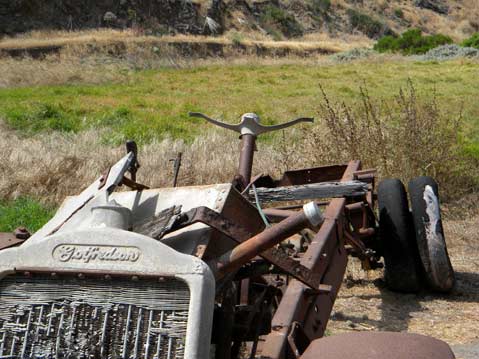
Outside of the visitor’s center is something of a graveyard of old ranching equipment. I found the rustic equipment juxtaposed with the nature conservation site to be a veritable photography playground. There are blacksmith shops with old chains and tools still hanging, and dark bat caves blocked off with ominous warning signs.
Sebine, our ever-knowledgeable naturalist, pointed out locations of ongoing projects to return native plants like the buckwheat, which on this island is white or pale pink as opposed to the red I saw on the others. There are also bushes of lemonade berry, which was soaked in water by the native Chumash to make a sweet beverage. To help these plants out, there are projects to eliminate foreign species, like the fennel and grasses that ranchers introduced to feed their sheep after all the native plants were eaten.
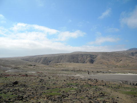
The island is even more desolate than the high grounds of Santa Rosa. The only native vegetation is on the steep hills; the rest of the island is barren, with large patches of dirt and eroded canyons.
Seeing the three islands together gives a clear picture of how fragile the land is. In Lobo Canyon, you see the past of the islands, a lush forest home to diverse plant and animal life. Then, in less than a mile along the Smith Highway, you see barren flatlands, eroded canyons, fences, and wandering foreign animals. The other two islands give a look at two possible futures for the island. On the one hand, there is Santa Cruz, where the constant presence of humans slows down the progress of restoring the natural condition of the island. On the other is San Miguel, where in 30 years, native life has been allowed return to a natural balance and is getting better all the time. It is clear that it is our responsibility to return the islands to what they once were.
4•1•1
For more information or to make reservations, call 962-1127 or visit truthaquatics.com.


