• CREATE AN ACCOUNT
  • LOG.IN
  • CONTENTS
  • CLASSIFIEDS
  • ARCHIVE
  • INFO | ADVERTISING | CONTACT US

  • Home
  • News
    • News Main Page
    • NewsFlash
  • A&E
    • A&E Main Page
    • Movie Times
    • TV Listings
    • A&E Blog
    • Art Galleries
    • Best Bets
  • Opinion
    • Opinion Main Page
    • Endorsements
    • Blogs
    • Columns
    • Voices
    • Letters
    • In Memoriam
    • Obituaries
  • Events
    • Today
    • Search
    • Submit
    • Best Bets
  • Living
    • Living Main Page
    • Outdoors
    • Travel
    • Sports
    • Peeps
  • Food & Drink
    • Food & Drink Main Page
    • All Restaurants
    • Delivery
    • All Bars & Clubs
    • Drink Specials
    • Open Now
  • Sports
  • Outdoors
    • Outdoors Main Page
    • Outside Insider
    • Spotlight On
    • Features
  • Classifieds
    • Real Estate
    • Jobs
    • Autos
  • Obits

    Ray Ford

    Fire fighters look eastward as the La Brea Fire advances up out of the Sisquoc drainage towards the Sierra Madres.


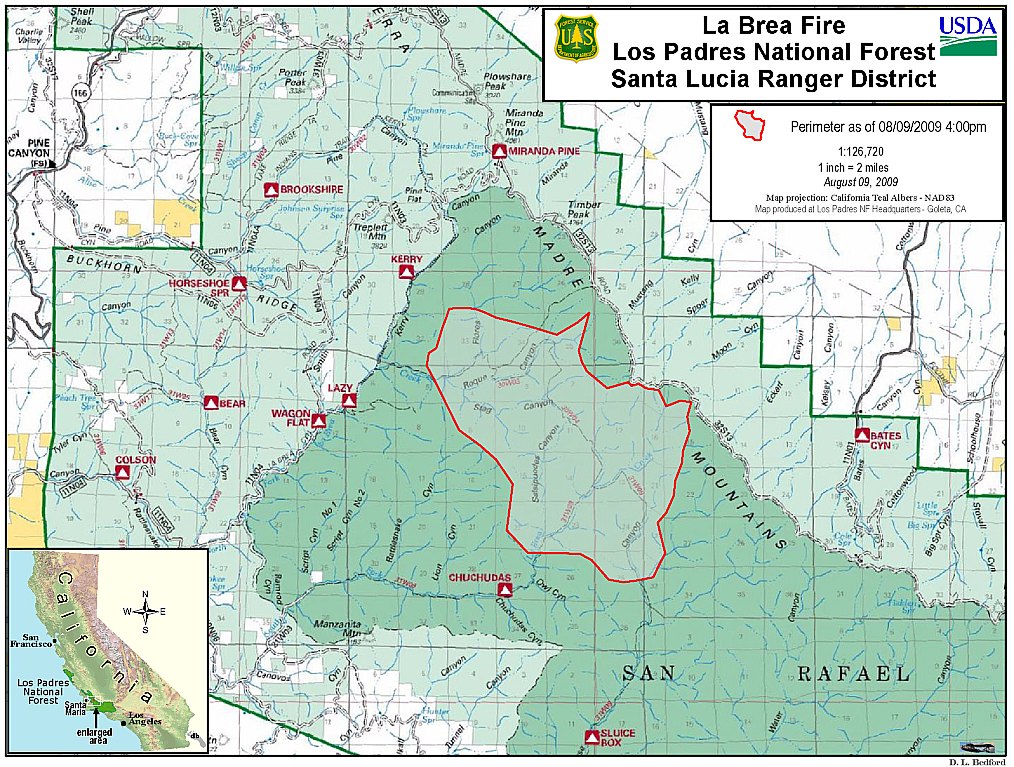
    La Brea Fire Pushes North and East

    Fire May Now Exceed 10,000 acres in size


    Sunday, August 9, 2009
    By Ray Ford (Contact)
    Article Tools
    Print friendly
    E-mail story
    Tip Us Off
    iPod friendly
    Comments
    Bookmark This
    del.icio.us. del.icio.us.
    Digg! Digg!
    furl furl
    google google
    newsvine newsvine
    reddit reddit
    technorati technorati
    Facebook Facebook
    Yahoo! My Web 2.0 Yahoo!

    As I headed towards Santa Maria via Highway 154, it was impossible to get a handle on how the La Brea Fire was progressing. Smoke was scattered through the sky, obliterating almost all of the distant mountains.

    La Brea Fire perimeter, as of 4pm August 9, 2009
    Click to enlarge photo

    Los Padres NF HQ

    La Brea Fire perimeter, as of 4pm August 9, 2009

    But by the time I passed Santa Maria and headed east on Highway 166 it became clear the fire was expanding. From Highway 101 it is just over 25 miles to the start of the Sierra Madre Road. Though dirt, it is very easy to drive, and in less than 10 miles of winding oak-and-grass covered hillsides lead to Miranda Pine Mountain and the first views of the fire.

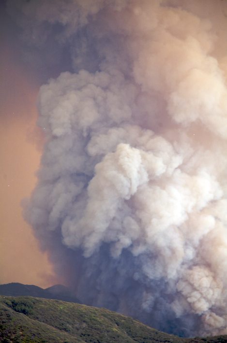
    The sky in front of me was filled with tall billowing clouds that varied in color from light tans to deep charcoal blacks. What I thought might be a one-day fire had turned ugly within less than 24 hours and was advancing quickly towards the Sierra Madre Ridge.

    Huge cumulus cloud filled with smoke, ask and burning material rises more than a thousand feet as the fire advances towards the Sierra Madre Ridge just east of Timber Peak.
    Click to enlarge photo

    Ray Ford

    Huge cumulus cloud filled with smoke, ask and burning material rises more than a thousand feet as the fire advances towards the Sierra Madre Ridge just east of Timber Peak.

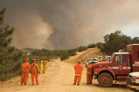
    Just east of Miranda Pine was a staging ground of sorts with hot shots, engine crews, CDF prison crews and an assortment of others awaiting assignment. The squawk on the radio was clear — the forces were getting ready for a major battle along the Sierra Madre Ridge. "Gonna be another Zaca Fire," one crew member ventured. "Gotta be over 10,000 acres by now," another said. "Hope you don't have any plans for the next week," someone else added.

    Look for a more detailed account of where things stand tomorrow after tonight's backfire operations. What is clear is that Santa Barbara has another big wildfire on its hands.

    Related Links

    • More La Brea Fire coverage
    Story Help (Click-ability)
    Double-clicking on any word or phrase in this story will open a reference window with definitions and links to other reference material.

    Comments

    Discussion Guidelines

    Why is it they could get air tankers to this fire ASAP (even though no structures are threatened) but they couldn't get them to Jesusita fire for 24 hours?

    Can someone PLEASE answer that question!?!

    Readers say: Thumbs Up: 0 of 3 • Thumbs Down: 3 of 3

    maximum (anonymous profile)
    August 9, 2009 at 10:17 p.m. (Suggest removal)

    There were choppers at Jesusita within the first hour and a half and I may be wrong but thought the fixed wings couldnt fly when the sundowners are blowing for safety reasons.

    Readers say: Thumbs Up: 2 of 2 • Thumbs Down: 0 of 2

    pointssouth (anonymous profile)
    August 9, 2009 at 10:57 p.m. (Suggest removal)

    I think the tankered lives in Santa maria...and I doubt anyone would withhold anything,
    equipment,resources etc
    The J fire had a phenominal lateral build and would lie flat during the sundowners
    you would be risking more trying to fly in those conditions....do we all get shaky the minute anyone says fire now?

    Readers say: Thumbs Up: 0 of 0 • Thumbs Down: 0 of 0

    gotosantorini (anonymous profile)
    August 9, 2009 at 11:24 p.m. (Suggest removal)

    Not a big fan of speculation, but the fire started ON opening day of rifle season in that section of the Los Padres National Forest.

    There's a good chance they will determine it was started by an open flame from a campfire or someone target practicing before a hunt.

    Just my two cents as to the possible cause, as many may be asking how a fire could have started in such a remote area with no lightning and lack of powerlines in the area.

    Again, I have absoultely no proof that this was the cause, but the timing seems rather coincidental.

    Readers say: Thumbs Up: 1 of 1 • Thumbs Down: 0 of 1

    steelhead88 (anonymous profile)
    August 10, 2009 at 7:42 a.m. (Suggest removal)

    Deer rifle season opens, welcoming drunken, driving, smoking, shooting "hunters" with somewhat less care and common sense than is prudent. Normally I love to go camping and hiking in the back country, but for the last few years I've avoided camping during deer rifle season because of the many reckless noisy "hunters". They overwhelm the careful quiet ones. We don't know for sure what started it yet, but I'll not be sursprised to find careless two legged critters to blame. Now that it's burning, let it go. It's a good cheap way to clear the old overgrowth.

    Readers say: Thumbs Up: 0 of 0 • Thumbs Down: 0 of 0

    builder777 (anonymous profile)
    August 10, 2009 at 8:39 a.m. (Suggest removal)

    Where can you get the latest update? Is a map too much to ask for?

    Readers say: Thumbs Up: 0 of 1 • Thumbs Down: 1 of 1

    aquagirl (anonymous profile)
    August 10, 2009 at 4:19 p.m. (Suggest removal)

    "Is a map too much to ask for?" -aquagirl

    Not to much to ask for, but difficult to provide. This article;
    http://www.independent.com/news/2009/aug...
    has a few maps made by Ray Ford of the latest information based at the time of his report.

    Inciweb also has a map of this fire which they provided at 4:30pm Monday, August 10. We have attached it to this story.
    http://inciweb.org/incident/1803/

    But no defined perimeters of the current blaze exist as it evolves. As the fire is in difficult to reach areas outside of populated areas, it is understandable, if frustrating.

    --WebAdmin

    webadmin (Indy Staff)
    August 10, 2009 at 4:51 p.m. (Suggest removal)

    thanks for the map...and Ray Ford!

    Readers say: Thumbs Up: 0 of 0 • Thumbs Down: 0 of 0

    aquagirl (anonymous profile)
    August 11, 2009 at 2:19 p.m. (Suggest removal)

    One thing I would like to mention is I believe there should be more prescribed burns. This would be better for the habitat. when you let the old growth get so old by suppressing it from natural fires like lighnening strikes, and don't forget the indians use to start the Forest on fire, they new it helped the enviroment.So anyway, what happens when there is to much old dead growth, is when it does burn, it burns so hot at the wrong time of year it can sterilize the area and it will take much longer for habitat to return.

    Readers say: Thumbs Up: 0 of 0 • Thumbs Down: 0 of 0

    Teri (anonymous profile)
    August 11, 2009 at 10:47 p.m. (Suggest removal)

    Post a comment

    Username:
    Password: (Forgotten your password?)

    Comment:

    EVENT CALENDAR

    Previous Month | Next Month

    Today's Events Best Bets Submit an Event

    Local Weather

    Currently:
    Clear Sky
    Temperature:
    61.0°
    Wind:
    6 WSW

    Surf Report
    • Specials
    • InPrint
    • Top Emails
    • Best Of 2009
    • 2009 Election Coverage
    • Wedding Guide 2009
    • Blue Green Guide 2009
    • SBIFF 2009
    • Tea Fire 2008
    • Local Heroes 2008
    • Calendar of Fundraisers
    • Local Bands
    • High Noon in the Garden of Controversy
    • CAMA Presents the Shanghai Symphony
    • Elings Park Expansion Shot Down
    • Before I Be Your Dog …
    • Flobots Return with New Record, New Vision
    • Autism Attacked Alternatively
    1. Eating Animals
    2. Producer Must Pay Landscaper
    3. Teacher in Trouble
    4. Montecito Pet Shop to Sell Only Rescued Dogs
    5. My Swine Flu Experience
    6. High Noon in the Garden of Controversy
    • CREATE AN ACCOUNT
    • LOG.IN
    • CONTENTS
    • CLASSIFIEDS
    • ARCHIVE
    • INFO | ADVERTISING | CONTACT US
    Google
     
    Independent.com Web
    Copyright ©2009 Santa Barbara Independent, Inc. Reproduction of material from any Independent.com pages without written permission is strictly prohibited. If you believe an Independent.com user or any material appearing on Independent.com is copyrighted material used without proper permission, please click here.
    This is our Privacy Policy.