Saving the Silence
Facing Threats from Inside and Out, the Carrizo Plain National Monument Prepares for the Future

Back in January 2001, during the waning days of the Bill Clinton administration, I pulled a press release off of The Santa Barbara Independent‘s fax machine announcing that the outgoing president had designated the Carrizo Plain a “national monument.” As a young reporter who took pride in covering the great outdoors, I was embarrassed to have never heard of a national monument – turns out it’s a Teddy Roosevelt-era tool that allows presidents to single-handedly protect significant landscapes – or of this obviously remarkable place located just north of Santa Barbara County. What made this plain special enough to be one of the last proclamations signed by an American president while in the White House?
The following weekend, three friends and I hopped into two pickup trucks and headed south on 101, east on highway 33 through Ojai and the Cuyama Valley, and, a couple hours later, hung a left onto Soda Lake Road, the monument’s main drag. After a twist (or three) in the road, the Carrizo Plain opened up like an earthen vault, its natural jewels spilling before our eyes and, when we killed our engines, we enjoyed a moment of serious silence.
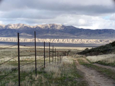
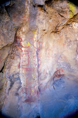
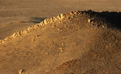
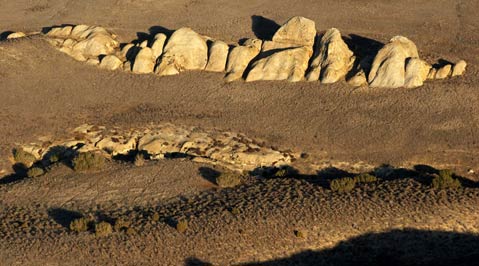
Encompassing 250,000 acres, the vast grasslands extended endlessly north, crept casually up the rolling hills to the east, and jutted violently into mountains on the west. The road soon turned to dirt before continuing all the way to the alkali-rimmed Soda Lake, a refuge for rare birds and rarer shrimp. Attempting to get a grip on the monument’s official significance, we stopped at the Goodwin Visitors’ Center, where we were encouraged to hike to Painted Rock, one of the few outcroppings on the otherwise uninterrupted plain. Painted Rock is one of the inland Chumash people’s most revered shrines, a three-story high, rocky womb adorned with detailed pictographs that still speak after years of weather and vandalism. If we weren’t already enchanted with the Carrizo, this spiritual experience sealed the deal.
As a wide-eyed 23-year-old, the seemingly lawless and limitless Carrizo gave me a tantalizing taste of unimpeded freedom and taught me a lasting lesson in the value of undeveloped landscapes-it’s crucial to have sanctuaries where urbanites can go get lost and then find themselves away from the traffic, noise, smog, and stress of the city. Nowadays, it’s the place I escape to-both physically and in my mind-when 21st-century stress wears me down.
As calm as it makes me feel, thinking of the Carrizo Plain National Monument also fills me with worry. Although it remains tranquil, it’s never been a more critical time for determining the future of the Carrizo Plain. As policymakers put the finishing touches on the monument’s official management plan-which has taken much longer than expected, due to official and personal politics-threats to the status quo loom both inside and outside its borders. From the oil and gas claims that cover nearly half of the protected acreage to the massive solar power plants being proposed just north of the monument’s border to debates over habitat restoration, cultural resources, grazing practices, to an increasing amount of visitors, all involved are debating vital issues about the future of the Carrizo Plain National Monument. The results of those discussions will reveal what we as Californians consider our priorities, and could have ramifications that will echo far beyond the silence of the Carrizo Plain.
Friends in Flat Places
The only way to digest the entirety of the 250,000 acres of the Carrizo Plain National Monument is from the sky, which is where I found myself last summer in a plane with pilot Chuck Jennings and passenger Mike “Doc” Malkin. I was in good hands: Both are members of the Friends of the Carrizo Plain, a volunteer organization that provides docents, builds trails, refurbishes historic buildings, remove old fences, and serves as the monument’s watchdog with an active email group, but stays out of the politics.
We took off from Santa Barbara Airport, flew over the erupting earth of Los Padres National Forest, looked down upon the tan and green patches of the Cuyama Valley, and climbed in elevation to clear the Caliente Range, stomping ground of the elusive mountain quail and the western border of the monument. We settled at about 7,500 feet above the Carrizo Plain, where the valley’s flat belly is ripped in two by the San Andreas Fault, which created the aptly named Temblor Range of rolling hills that serve as the monument’s eastern border. “It reminds me of an alligator’s tail,” said Jennings as he swooped us closer to the fault and explained that we could follow the crack all the way to San Francisco. Our goal for the day was to locate wandering herds of tule elk and pronghorn antelope, but the flight also gave me ample time to get a refresher course from my companions in the basics of the Carrizo.
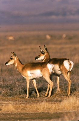
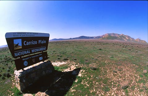
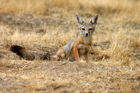
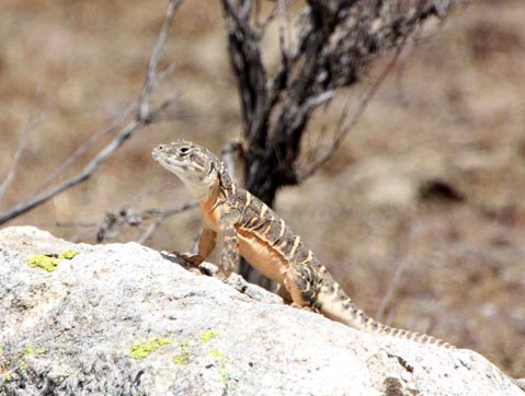
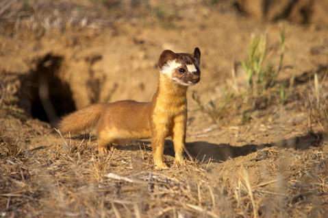
Located in the southeastern corner of San Luis Obispo County, owned by the federal Bureau of Land Management (BLM), and operated in partnership with the Nature Conservancy and the state Department of Fish & Game, the Carrizo Plain National Monument is home to more specially protected animal and plant species than almost anywhere in the country-from the kit fox, kangaroo rat, antelope squirrel, and blunt-nosed leopard lizard to the jewelflower, woolly-threads, and Hoover’s woolly-star. The 38-mile-long, 17-mile-wide Carrizo is considered to be the last vestige of what the 300-mile-long San Joaquin Valley looked like before agriculture took over; its ecosystem essentially extends another 50 or so miles to the north toward Highway 46 east of Paso Robles. “This is the last remaining facsimile of the grasslands that once covered all of California,” explained Malkin over the rumble of the propeller. “When it’s gone, it’s gone.” Throw in the antelope, elk, a few roving coyotes and cougars, eagles of the bald and golden variety, some fairy shrimp, songbirds galore, and the occasional California condor, and there’s little wonder why Carrizo has been called “California’s Serengeti.”
Malkin, a former drama professor at Cal Poly and father of The Indy‘s marketing director Jen, had invited me on the trip because he’d like to see more Santa Barbara participation in Friends of the Carrizo Plain. The organization has members from Los Angeles and even the Bay Area, but no one from our town, which Malkin finds odd since we take so much pride in our environmentalism. “We’d like to grow,” explained Malkin, whose group must pick up a lot of slack since national monuments, compared to national parks, are given less funding for habitat restoration, recreation, and other needs.
With no luck finding the ungulate herds, Jennings took us on an aerial tour of the Carrizo’s historic homesteads, farms where people survived for generations by growing barley and winter wheat and ranches where cattle and sheep paid the bills. But less and less rainfall turned the already dry area more parched throughout the decades, forcing most folks to move on but allowing nature to fill in the void. By the mid 1980s, the Nature Conservancy teamed up with the BLM to create the Carrizo Plain Natural Area, which they did by buying more than 80,000 acres from land investment company Oppenheimer Industries in 1988. Congress kicked in money for another 50,000-plus acres within two years, and since then, smaller purchases have grown the monument to a quarter-million acres.
However, the protections, even as a national monument, remain somewhat tenuous, in large part due to the potential wealth of oil and gas that sit below the monument’s surface. That reality is hammered home on our plane flight, as the rig-saturated oil fields of Kern County are visible just on the other side of the Temblors and derricks also pop up in the Cuyama Valley on the far side of Caliente Peak. “There’s oil east of the Carrizo and there’s oil west of the Carrizo,” Malkin explained. Today, valid mineral resource claims exist on more than 100,000 acres of the monument; any development could have disastrous impacts on the Carrizo’s critters and calmness.
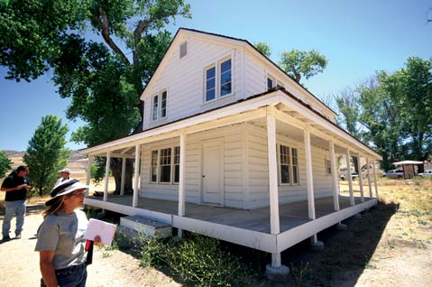
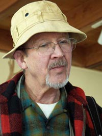
To get a closer look, I drove Carrizo Plain later that week to meet up again with Malkin, who was joined by the monument’s wildlife biologist Kathy Sharum and Roger Gambs, a retired biology professor from Cal Poly who’s active with Friends of the Carrizo Plain. After looking through binoculars at red-tailed hawk chicks and watching a kestrel battle a barn owl in broad daylight, we walked around the recently renovated El Saucito Ranch, the oldest standing structure on the plains and, in the late 1800s, the only residence for 600 square miles.
Remodeling old ranch homes is probably one of the least controversial jobs for Sharum and monument manager Johna Hurl. Both seem to spend a great deal more time dealing with the more difficult challenge of habitat restoration, which has become a hot button issue for those who’d rather use the monument for livestock grazing, hunting, off-road driving, and other potentially damaging activities. Some of these folks criticize native plant and animal restoration by saying that the genie of modern impacts and introduced species simply cannot be put back in the pre-European contact bottle. “I don’t think any of us want to play God,” Sharum told me that day at the monument’s KCL Campground, where numerous orange flags, denoting kit fox and kangaroo rat dens, flapped in the midday wind. “We don’t have the perfect ecosystem,” she admitted. “But realistically, you work with what you have.”
Compared to other ruined landscapes across the world, the Carrizo isn’t too far off from its original form. That gives Sharum, Malkin, Gambs, and all the members of Friends of the Carrizo Plain hope for the future. Explained Gambs, while in the shade of a dilapidated barn with a telephoto lens around his neck, “We are trying to get the Carrizo up there with what could someday be an internationally recognized model of how a national monument ought to operate.”
Planning for the Plains
The most crucial part of that model is the monument’s management plan, which is nearing completion with the public comment period ending April 23. Today, everyone involved-from the BLM to its nine-member advisory committee to those watching from the sidelines, including Friends of the Carrizo Plains-is satisfied with the progress. But it wasn’t always that way.
Soon after the monument was created in 2001, 13-year BLM veteran Marlene Braun was named manager. Having been stationed in Alaska and Nevada, the workaholic Braun finally felt at home on the Carrizo, and took intense pride in protecting it. She scaled back grazing on sensitive grasslands and began developing the monument’s first management plan, which would phase out long-term livestock permits. Every agency signed on, even the BLM’s California office. Then, in March 2004, the Bush administration-which was critical of Clinton’s last-minute monument designations-appointed Ron Huntsinger as Braun’s supervisor in BLM’s Bakersfield field office. With marching orders to favor ranching over preservation and “fix this plan,” Huntsinger and Braun became immediate enemies. The two butted heads repeatedly, so much so that in May 2005, Braun-who had also been dealing with her own psychological demons-arranged her personal affairs and wrote a few important letters about her fears for the Carrizo. She then took a .38 caliber revolver, killed her two dogs-neatly placing their bodies under a quilt-and turned the gun on herself.
Braun’s suicide shocked the region, resulted in a federal investigation, and eventually led to Huntsinger’s transfer. The management plan was the fourth casualty. “The whole process imploded. It collapsed,” explained Neil Havlik, who was named to the monument’s advisory committee when it was created in 2002. “It was finally decided that the process should start all over again.” Relations soured between the Carrizo staff and the BLM higher-ups. “That trust took time to rebuild,” said Havlik, the City of San Luis Obispo’s natural resources manager, “but it has been rebuilt.” That’s thanks in large part to the appointment of Tim Smith as the BLM field supervisor in Bakersfield, who Havlik called a “really great guy.”
Nearly four years after Braun’s suicide, the current plan reflects her vision. “I am very happy with the plan,” said Havlik, who’s spent much of his last 13 years at the City of S.L.O. protecting open space. “It is setting policies that are progressive, that are going to be responsive to scientific recommendations and input.” Specifically, the plan addresses grazing, mineral extraction, cultural resource protection, wilderness designation, and roads, and has proposed three alternatives that range from more hands-off management to intense involvement. The BLM staff’s preferred alternative is number two, which blends the two more extreme alternatives, encourages a “moderate” expansion of wilderness zones (where no motorized vehicles are allowed), reduces the redundant roadways, only allows grazing for “vegetation management,” stabilizes historic sites, and makes Painted Rock accessible only by permit or tour.
Since BLM is an agency that traditionally allows extractive industries, the management plan does not affect the “valid and existing” mineral rights that cover about 100,000 acres of the monument, including four active wells in the Caliente Range. Any attempt to eliminate those surely would have led to a massive fight, but if a recent response to an oil-drilling proposal is any indication, the monument is in good hands.
That proposal came during the oil price spike of late 2007 from oil company Vintage Production, which announced its intent to do seismic testing on its 30,000 acres of mineral holdings on the valley floor. Testing would involve “thumper trucks” that send soundwaves into the Earth to look for oil and gas. That process, said Helen O’Shea of the Natural Resources Defense Council, “is particularly damaging in an environment like the Carrizo where you have animals like the kit fox and kangaroo rat that actually live underground.” When presented with this proposal, the BLM had multiple options, but they chose the strictest and asked Vintage for a full Environmental Impact Statement. Months later, the oil company has not yet responded. “We’re very pleased to see the BLM choose appropriately and hold the applicant to the highest possible standard,” said O’Shea. Future drilling proposals, one may presume, will likely face similarly strict scrutiny.
One thing that’s not controllable is the number of visitors; increased use is something that’s worried former S.L.O. County supervisor Jerry Diefenderfer ever since it became a monument in 2001. A fourth generation Carrizo-dweller whose family has been ranching in the area since 1865, Diefenderfer was involved in the initial BLM acquisition in the ’80s, but thought a monument designation was “premature.” Diefenderfer, a former president of Friends of the Carrizo Plain, believes there is still not enough staff to watch over the quarter-million acres, even with only about 3,000 counted visitors per year. Indeed, anyone who spends much time on the Carrizo is bound to see some bizarre human activity-there’ve been accounts of drug-running, meth-making, body-dropping, sports car-burning, and the like for years. “I know a lot of people would like to have more activity there,” said Diefenderfer. “But I think it would be unhealthy for the monument to have that, simply because we’re not geared to handle a large number of people. And I quietly hope that day is a long way away.”
His government-fearing neighbor Darrell Twisselman, whose family has been on the Carrizo since the 1880s, agrees, and loudly. “The reason the endangered species [are] still there is because there was nothing out there but a few old farmers,” he explained in his good-ole-boy twang. “Now they’re bringing all kinds of people out there and they’re gonna defeat their purpose.” When the Wilderness Society tried to establish the Carrizo as a UNESCO World Heritage Site-which would have upped its international appeal-Twisselman “fought the hell out of that. You’d get 20,000 tourists running around here. That’s no way to protect your endangered species.” That campaign, which requires regional support, was shot down by S.L.O. County supervisors in March 2007.
For all his anti-environmentalist ire, Twisselman did play a major role in making the Carrizo what it is today. In the late 1980s, he helped the Department of Fish & Game reintroduce the pronghorn antelope and tule elk to the Carrizo, driving them down himself from Mount Shasta. Nowadays, he allows people to hunt them on his land for a fee, and laughs when people cite them as some sort of threatened species. The self-proclaimed “true environmentalist” who believes the environmental movement has turned into a power-grab, recommends “building a big fence around it and getting away from it. Of course,” Twisselman continued with a chuckle, “I’m not very popular with those guys.”
Though the monument can’t physically restrict visitors from driving through, Havlik assured that the management plan is not designed to attract hordes of people. “In some ways, this is the place where time has gone backward,” he said. “The opportunity for solitude and reflection is really a great thing, and that’s one of the things I think everybody appreciates about the monument. We don’t want to make it into Disneyland. We don’t want a lot of attractions out there. The natural environment is the attraction.”
Solar Dreams, Eco-Nightmares?
While the monument’s managers may not be setting up the Carrizo as the “happiest place on Earth,” no one can deny it’s one of the sunniest. Pair that with cheap land, existing electrical transmission lines, and political pressure from both the state and feds for renewable energy, and it’s easy to understand why the lands just north of the monument’s border are being targeted for the most massive solar power plants on the planet. When combined, these proposed plants-two photovoltaic, under review by S.L.O. County, and one solar thermal, under review by the California Energy Commission-would provide energy to nearly 100,000 homes but only by covering more than 16 square miles of the valley floor, an area nearly the size of the City of Santa Barbara. If all are approved-and there’s plenty of motivation in the federal stimulus plan, which will pay for 30 percent of projects that begin construction by 2010-many fear that the solar plants would block migration patterns for the kit fox, antelope, and other species, threaten Soda Lake by tapping an already overburdened groundwater basin, and damage views irrevocably.
“I live right in the middle of it,” said Mike Strobridge, an auto mechanic who lives with his daughter in a house near the monument that would be surrounded by the proposed plants. “It’s peaceful. I love the wildlife. Then these solar guys come in and they’re just gonna destroy the area.”
Robin Bell, who is building a retirement home about a quarter-mile away from a proposed plant, is worried, too, and has formed the Carrisa Alliance for Responsible Energy, or CARE. (“Carrisa Plains” is a colloquial name for the area.) She explained, “I personally feel strongly that all these rules and regulations are in place for a reason, and, in the name of being green, these power companies are exploiting that.” Bell favors distributed renewable energy, i.e., solar panels on homes and businesses throughout the state. “I totally support the development of renewable energy, but at what cost?” she asked. “This area has one of the highest concentrations of special species in the state. To me, it seems like the last place you should be doing this.”
Bell is also watching two bills moving through the state legislature that, if passed, would put all renewable energy projects under the control of a new state commission. (Currently, photovoltaic projects are reviewed by counties and industrial-type plants, such as solar thermal, are reviewed by the state.) Bell fears the bills would streamline the process too quickly and eliminate all local control.
The specific effect on the monument remains to be seen. But Mary Strobridge, a member of CARE and mother of Mike, is concerned the plants would ruin anyone’s experience who visited the monument from the northern entrance. “It would just be devastating to drive into the Carrisa Plains and see a 10-story tall industrial solar plant right smack dab in the middle of it, with 640 acres of pipes and mirrors and around that photovoltaic cells going on for thousands and thousands of acres,” she said. “It just doesn’t make sense to me.”
Making sense of the two photovoltaic projects is the job of John McKenzie, a planner with the County of San Luis Obispo. Among other issues, he’s analyzing migration corridors, groundwater limitations, and the loss of ag land. “It’s really a quandary for a lot of people,” he said. “It does try to address a huge environmental problem, but it’s at the potential expense of some more localized environmental problems. It’s one of those very difficult issues.” More frightening, however, is that no one’s really had to review projects such as these ever before. McKenzie has “zero” experience in doing so. “These are the two biggest plants in the world,” he said. “This county is getting to be one of the first folks to deal with it.”
The third project-a solar thermal plant proposed by Australian company Ausra that uses sun power to heat water to turn turbines-is considered more industrial, so it falls under the purview of the California Energy Commission. But even that commission is still getting up to speed with projects of this type. Said its chairperson Karen Douglas, “We’ve got much more experience siting natural-gas plants than siting renewables, both from a staff and commission perspective. So some issues are rising up in the renewables case that are substantively different than what has been the core of the siting work before the solar applications started coming in so quickly.” There are ongoing studies of how to incorporate renewable projects while protecting ecosystems-studies Douglas hopes “will be a model for how we can get this done”-but those are strictly for the Mojave Desert, and currently have no bearing on the Carrizo.
The solar power companies, however, believe the time and location are right. Ausra’s Katherine Potter explained, “There is certainly a good place for distributed generation, but to ensure the reliability of the grid, you do need large-scale power generation.” Added Alan Bernheimer of OptiSolar, which proposed one of the photovoltaic projects (but recently sold to First Solar), “We need all the solar power we can get, both distributed and large-scale. It’s not a question of either/or. It’s both.”
For Darrell Twisselman, who is selling his land to the photovoltaic projects, the debate is a bunch of “people protesting for the sake of protesting.” He remembers when a small solar plant was built there in the 1980s, only to be torn out later when the technology failed. “Everyone complained about them for two weeks, and then everyone forgot,” Twisselman said. “And they were what you might say unsightly. You could see them from everywhere.”
As the solar projects move forward and analysts begin to assess potential impacts to the monument, Mike Strobridge is holding his ground. “At this point, we’re frustrated and doing everything we can to make sure if something does come in, it’s put in responsibly.” And that’s about all anyone else can ask for.
Breathe Deep
Amid the debates over solar projects and monument management, one point was uttered by almost every one of the more than 20 people contacted for this article: The Carrizo is not for everyone. “You either get it or you don’t,” exclaimed biologist Roger Gambs. “There is no in between!” Echoed rancher and former politician Jerry Diefenderfer, “I’m not sure what it is, but I do know that in my 65 years of lifetime, everybody I’ve dealt with on the Carrizo Plain, they either love it or they hate it.”
Flat, bleak, dry, and desolate, the region turns off those scared of solitude, those who don’t appreciate the silent stillness, those who aren’t impressed by rare species of plants and animals. But like a good book, those who continue reading the Carrizo will find that its characters are rich, its storyline quite deep, and its value immeasurable.
Since my initial visit eight years ago, I’ve returned sporadically, sometimes with friends in search of cave paintings, curious creatures, and campground camaraderie, but also alone, with a bike, a camera, and a few hours to kill via quiet contemplation. It’s a place to retreat and recharge, and my constant reminder to breathe deep. This place where time moves backward is worth a visit in any season, and we should all hope it stays that way.
4•1•1
To learn more about the Carrizo Plain National Monument and/or to join the Friends of Carrizo Plain, see carrizo.org. To comment on the management plan, email cacarrizormp@ca.blm.gov.