
Reyes Peak Hike
High Country Views Atop Pine Mountain and a Mellow Day Hike

HIKE INFORMATION
Distance-7 miles round trip to the summit of Reyes Peak
Elevation Gain-1,600′ to the summit but relatively level the first several miles
Trail Conditions– Trail is in good shape
Difficulty-Easy first several miles, moderate for the entire round trip
GETTING THERE
Take Hwy. 101 to the outskirts of Ventura and turn north on Hwy. 33. Follow this for 10 miles until you are almost into Ojai and look for the point where Hwy. 33 turns left and heads up into the backcountry. From there it is a bit more than 30 miles to the Pine Mountain turnoff. Look for it just after Milepost 42. From there it is 7 miles to the trailhead.
THINGS TO KNOW
No gas or food beyond Ojai and you’ll need an Adventure Pass. Wheeler Gorge Visitor Center is open on the weekends and you can get maps, info and passes there. Otherwise, get what you need in the Ojai area before you head up Hwy. 33.
SCENIC NOTES
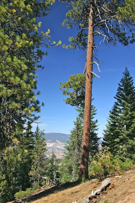
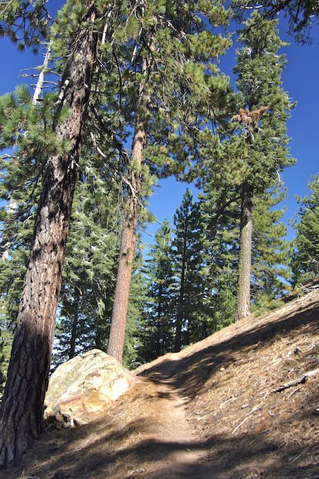
As you make your way up the road (it’s a bit rough even though paved but passable for even the lowest slung vehicles) the chaparral gives way to a scattering of Ponderosa and Jeffrey pines and before you know it you are in solid forest. With the exception of Mt. Pinos and Figueroa Mountain, this is the only place in the southern Los Padres National Forest you can drive up into stands of Sierra-like trees such as here. However, with the views in either direction, the massive sandstone boulders that dot the landscape and the feeling of being on top of the world, there is no better place to get out into what some would call a “real forest”.
Getting to Pine Mountain is relatively straight forward, though from Santa Barbara it’s a bit of a drive. Fortunately, the drive north on Hwy. 33 is overwhelmingly beautiful (Hwy. 33 is a national scenic highway), Stops along the way in Wheeler Gorge (for information) or at many of the turnouts along the road will stretch out the drive even a bit more, but they’re worth it.
Among them include the turnoff to Rose Valley which provides access to a handful of other day hikes as well as access to the Sespe Wilderness, the rock climbing wall about 10 miles further up the road as well as several day hike routes that lead north up toward the Pine Mountain range. More about these in another article.
You’ll spot the Pine Mountain turnoff a bit after Milepost 42 and at the saddle that marks the upper end of the Sespe drainage and that of the Cuyama. Once you’re on the summit road (LP Forest Road 6N06) it’s seven slow miles to the top, but with the views you won’t mind too much. There are several picnic areas along the way, all placed in spectacular pine and sandstone settings, so a picnic after the hike at one of these will provide a pretty nice way to end the day. There is also a limited number of camp spots here as well (first come, first served) so it’s possible to make this a weekend retreat too.
Several reminders about this part of the forest. There is no food or fuel to be had beyond Ojai so if you need either make sure you’ve got both before heading on up Hwy. 33. The Wheeler Gorge Visitor Center is open on the weekends and you can get a few additional items there, including maps and interpretive guides as well as have your questions answered. Yes you will need an Adventure Pass, which will set you back $5 for the day.
THE HIKE
At the seven mile point you’ll reach the end of the road. Here, you’re at the Reyes Peak parking area and the start of the Sespe Wilderness. The hike out to Reyes Peak (7,514 foot elevation) and back will take several hours, which might sound like a bit of time but the hiking is fantastic: loads of forest, beautiful sandstone, great views and most remarkable of all, the ridgetop hike is mostly level with short ups and downs most of the way out along it.

The trail continues on into the Sespe Wilderness, with opportunities for a variety of different extended backpack trips off the edge of the ridge either down into the Cuyama, the Sespe River or continuing much further east into the Mount Pinos District near Mutau Flats. The key is: go as far as you like, stop a lot, enjoy the views and perhaps even find a place to snuggle down for an afternoon nap. This is one of those places where you’ll find yourself having so much fun that it will be hard to slow down, yet the feeling is so peaceful up here that at another moment you’ll be wanting to find just the right place to sit for a bit to soak it all in.
To reach Reyes Peak you will need to do some additional climbing, but it isn’t difficult walking. The trail is well maintained and the distractions from the uphill effort toward the end of the hike make it much easier than you’d think. Go as far as time or energy will allow: no matter where you stop and head back you’ll find the hike just right.
HISTORY OF REYES PEAK
Hundred Peaks Section of the Sierra Club
Named for Rafael Reyes (ca.1834-1890), who settled with his family at the mouth of Reyes Creek (1854). Drought forced them to move from their Rancho Triunfo (2 miles southeast of Thousand Oaks) to the Cuyama Valley in search of better grazing conditions. They managed to transfer 2000 cattle and 1000 horses through the Tejon Pass.
He is also remembered for his odd insistence that his was the property that once contained the fabulous Lost Padres Mine! But alas, he swore that its (imaginary?) deposits of limitless silver and gold dropped before his very eyes into cavernous fissures that opened and closed during a series of earthquakes before he could exploit his find.
Jacinto Reyes, his son, was almost as legendary as USFS District Ranger of the old Santa Barbara National Forest (1901-32). He became known as the “Dean of California Rangers”. In those days it sometimes took ten days for messages to get through to his remote post in Cuyama, but Reyes and his famous mule (who would work for no other), were frequently at the center of daring rescues and famous manhunts. In 1910 alone he almost single-handedly planted 163 acres with Jeffrey Pine in the Lockwood and Piru areas.
The USFS constructed a fire lookout on Reyes Peak consisting of a 14′ timber tower with a 14′ x 14′ wood cab (ca.1925). The peak name was first mentioned in the Ventura County Directory (1898) and first appears on the GLO State of California map (1907).
Reyes Peak was on the original 1946 HPS Peak List and was climbed by Weldon Heald in 1941.


