Waves of Weirdness

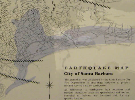
Above is a detail of the Santa Barbara tsunami map. Too see a larger version, click here.
Humans, as a species, have a remarkable facility for ignoring what’s precisely in front of their noses in order to fixate on something less immediately relevant. For example: in the midst of all the brouhaha over global warming, and the possibility that all of us will perish in some kind of burning desert or possible icy apocalypse – the scientists aren’t entirely clear on that Santa Barbara residents manage to overlook the fact that this is one of the most seismically active areas in the nation.
Now, I’m not a fear-monger. I just have an unhealthy obsession with natural disasters – specifically tidal waves, or tsunamis, if one chooses the technical term. The idea of Santa Barbara being obliterated by enormous, unstoppable walls of water is one which many of you don’t contemplate on a daily basis. Thankfully, Weird Santa Barbara – and the Santa Barbara County Fire Department – are here to do it for you.
As some people will already know, Santa Barbara was hit with a series of tidal waves following a massive earthquake in 1812. An earthquake measuring 8.3 on the Richter scale struck on December 21, with an epicenter off the coast a little to the west of Santa Barbara. The Santa Barbara Mission was reduced to rubble, not to be rebuilt until 1820.
And then the fun began. Five massive tsunamis, the last two topping out at 48-50 feet high, pummeled Santa Barbara and made it all the way to the Presidio. Fleeing in terror, the inhabitants lucky enough to escape made it to the Mission, where they stood in the ruins and watched as their home was destroyed by gigantic and implacable tidal waves. To put this in perspective, the Granada Theater is about 96 feet high had it been there, the waves would have been half as tall.
Cool.
Making it even cooler, the earthquake hit, as it happened, more or less in the only place where it could have caused such a disaster. An earthquake centered on shore wouldn’t cause enough disruption in the ocean, and tidal waves from an earthquake farther out to sea would be buffered by the Channel Islands. So we got lucky, in a sense.
But the question on everyone’s minds really should be this: Are we likely to get so lucky again? The Fire Department isn’t sure, but based on surveys and scientific data, they’ve made a map (see the above link) estimating how much damage another 50-foot tsunami would do should it occur again. The area shaded in blue is where you don’t want to be, and the red dot marks the offices of the Independent -which, everyone will be relieved to know, would be safe.
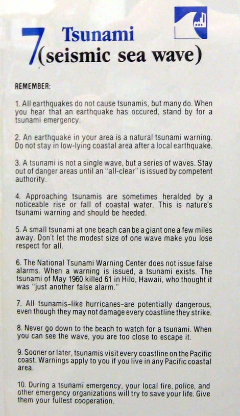
If you live or work in the blue shaded area, however, the Fire Department has safety tips to offer. One of the most helpful is number eight: “Never go down to the beach to watch for a tsunami. When you can see the wave, you are too close to escape it.”
Good advice indeed – though if you need it, you have bigger problems than just a giant wave.