

With favorable weather patterns and the tireless work of firefighters on the front lines to thank, Santa Barbara residents living in the ashy shadow of the Zaca Fire were breathing a little easier this week. Seemingly sparing closer-to-home locales like Paradise Road and East Camino Cielo, the still-raging inferno had, as of press time, turned its radically destructive front lines toward the north and east, continuing its flaming mastication of the Dick Smith Wilderness and the forest land around Santa Barbara Canyon. Even as the massive scar of burned-out land broke the 105,000-acre mark-making Zaca the largest forest fire in the history of the county-and arguably the driest and hottest weather of the blaze’s six-week run plagued containment efforts, fire officials unilaterally expressed optimism this week about the safety of the South Coast and strength of fire lines cut by both hand crews and bulldozers since the post-Fiesta flareup.
“Things are a whole lot more optimistic than they were even a few days ago,” said Forest Service spokesperson Steve Till on Tuesday, August 14. “Absolutely there is still a threat, but it is nowhere near the danger it was last week.” As reassuring as his words were, perhaps the most telling sign of positive progress was the fact that not only has Highway 154 been reopened but evacuation orders for Paradise Road and Happy Valley residents were lifted over the weekend.
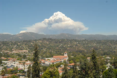
Seven days ago, the panic-both real and imagined-was running wild. Emergency town hall meetings were called in Montecito, Santa Barbara, and Ojai while somewhat sensationalistic emails bounced around offices heralding doomsday scenarios. All the while, mushroom-cloud smoke plumes simmered along the Santa Ynez Mountain ridgeline, providing an ever-present reminder of the blaze burning in the valleys beyond, sometimes just miles from Paradise Road and the Santa Ynez River. With weather reports predicting troublesome north winds and the possibility of flame-fueling “sundowners,” officials were bracing for the worst, and evacuation plans were being drafted.
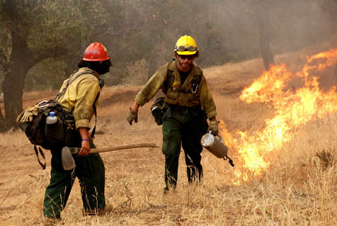
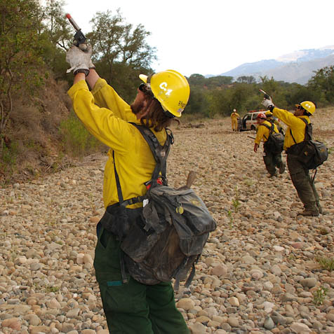
However, in the days since, the fire’s southern run has been all but halted by heroic efforts from fire crews. Everything from Hot Shot teams rappelling from helicopters down into fire-riddled canyons to a huge DC-10 flying in from Victorville to drop as much as 12,000 gallons of fire retardant at a time helped to stop the southern movement of the fire. Dozens of miles of direct hand lines were cut under the most hostile of conditions. And extensive dozer lines and fire breaks aim not only to provide insurance should Zaca experience a southern resurgence, but also to offer fire protection in years to come. In fact, the progress made last week has, to date, allowed the Forest Service to put its controversial front-country back-firing plans on indefinite hold. That being said, the fire can always change, one fire official noted. “As always, this fire is going to go wherever the weather puts it, and nothing we do is going to change that,” he said.
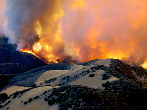
As much as the past week has seen improving fire conditions, it has also seen some extreme action along the northern and eastern borders of the inferno near the Sisquoc River, Samon Peak, and Highway 33 several miles beyond. Coupled with back-burning operations in the aforementioned area, the recent runs have seen the fire grow substantially to approximately 156 square miles-nearly eight times the size of the City of Santa Barbara-with about 25 miles of unchecked burning perimeter. Furthermore, as evidenced by the massive smoke cloud that towered above downtown Santa Barbara on Tuesday afternoon, the fire continues to ignite previously unburned patches that exist well within its controlled borders. Though these burns are dramatic, visible, and often responsible for raining ash, they are-according to experts-relatively harmless and rarely indicative of a deteriorating situation. – Ethan Stewart
Incident Command
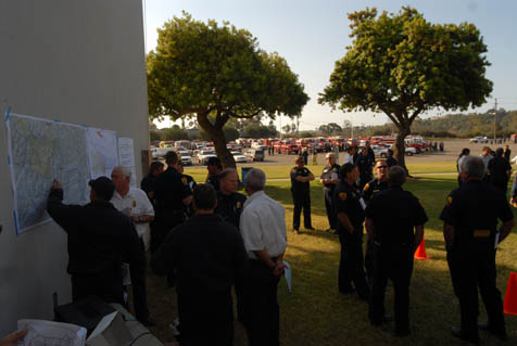
In the early days of the Zaca Fire, when it became obvious that the blaze would require firefighting resources beyond local capabilities, a U.S. Forest Service Incident Command Unit (ICU) was called into action-erecting a full-service base camp at Live Oak Campground. Considered by many in Washington, including military personnel, to be the most efficient form of disaster response that our government has, the ICU methodology was developed in the 1970s-with input from, among others, Santa Barbara County firefighters-as a uniform way for city, county, state, and federal agencies to work together and better fight forest fires in Southern California. In the years since, the ICU recipe for response has been duplicated by many government agencies and, in 2004, the Department of Homeland Security issued a comprehensive national system for responding to all major disasters that is predicated specifically on the ICU system.
Characterized by a strict paramilitary chain of command, around-the-clock strategic planning sessions, and an almost obsessive commitment to teamwork, the ICU system was described recently by one Live Oak participant as “30 complete strangers coming together and doing their jobs in perfect harmony.” Beyond the high-ranking tactical team of local and national firefighting experts, the Live Oak camp features a virtual city of support services that includes a full-service mess hall (offering up everything from chicken cordon bleu to bananas Foster), weekly church services, a chainsaw repair shop, fuel stations, map makers, meteorologists, doctors, nurses, and dozens of fire crews from across the country.
Since the Live Oak headquarters opened in early July, the Zaca Fire’s continued growth to the northeast and south has required the opening of two additional ICU operations-one at Earl Warren Showgrounds in Santa Barbara and one near New Cuyama at the Richardson Camp. Each of these locations has its own similar though separate chain of command and fabric of support services. Speaking recently at the Santa Barbara County Board of Supervisors meeting, Earl Warren ICU Commander Rick Henson said of the entire operation, “I’ve been doing this for 30 years, and I have never seen an operation quite like this. The cooperation has just been outstanding. Everybody dropped their egos and personal agendas and came together to fight this fire.” – Ethan Stewart
Air Quality
The Zaca Fire has now consumed more than two million tons of backcountry fuel, belching up massive quantities of smoke, ash, and other air pollutants. According to certain laws of physics, what goes up must come down. But fortunately for Santa Barbara residents, what’s coming down isn’t necessarily doing so here. Satellite images of the smoke indicate that it may have been traced as far away as Idaho and Nevada. But the people of Kern County have smelled it with sufficient pungency to fear that the flames were imminently upon them when in fact they were more than 25 miles away. According to the Santa Barbara County Air Pollution Control District, the Zaca Fire has already produced 16 times more particulate matter than all the cars, trucks, and buses on Santa Barbara County roads cough up in a year. Likewise, the fire has produced 4.1 times as many reactive organic gases and 118 percent as much nitrogen oxide. Responding to the short-term consequences of all this smoke, the Air Pollution Control District has issued numerous public health advisories, warning people to avoid energetic exercise when they can smell the smoke. But the long-term impacts are less clear because many of these smoke-choked vapors are taken 30,000 feet up into the air and then blown into other counties and other states. – Nick Welsh
The Mapmakers
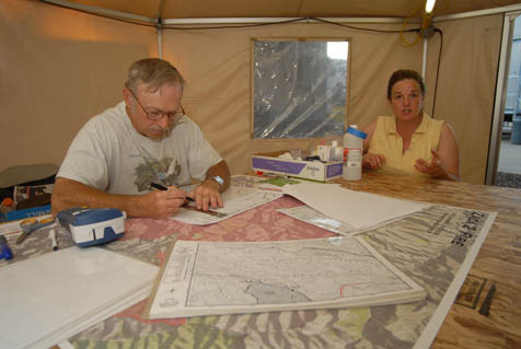
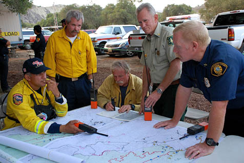
Whether you are a firefighter with one foot in the green and one in the black, a strategist in an air-conditioned trailer, or a freaked-out citizen in downtown Santa Barbara, updated and accurate maps of the Zaca Fire are your lifeblood. Constantly crunching data and plotting GPS coordinates, people like Mike McHargue (far right) are fundamental in turning raw information into the easy-to-understand maps we all know and love. While computers do the bulk of the work, maps are also still hand-drawn by the likes of Stacey Fiori and Travis Worthen (from Alaska and Oregon, respectively) to ensure that the information is available even in the face of a power outage or technical snafu (left).
A sense of almost perpetual motion pervades the Live Oak fire camp; time-lapse photography would reveal a blur of activity. Yet amid all this, one trailer receives few visitors. Inside is what is known as the “inner sanctum”-ground zero for the development of all of the operation maps used by incident commanders, planners, field commanders, and the crews.
If the maps aren’t accurate, the consequences can be serious; inaccurate information can cost lives. Some mapmakers wear earplugs to keep out distractions as their concentration needs to be super-focused.
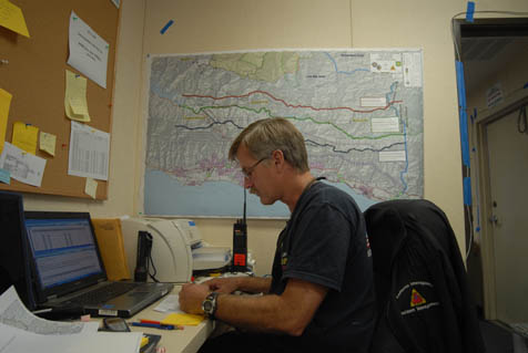
Infrared information showing active fire lines needs to be updated two or three times a day, as field commanders radio in information about new dozer lines, shifts in the location of resources, or extensions of containment trails. FOBs (field observer crews) with handheld GPS units will also be out walking fire lines and sending in data. If there are changes to water sources and landing locations, those need to be added for the helicopters. Locations of the spike camps-remote camps near fire lines-as well as safety zones and crews are also updated constantly. In-camp Planning, Operations, Logistics, Resources, and others will be giving constant input as well.
Beginning their day at between 3 and 4 p.m. when the information starts flowing in, these people will be redrawing maps using the latest information over the next six hours. As the fire moves, the map’s boundaries will need to move as well. Around midnight, the mapmakers begin printing the 75-100 copies needed for the 6 a.m. briefing as well as for camp operations and field crews. At 36Ê° tall and 60Ê° wide, each map takes about 20 minutes to print out on one of several plotters capable of handling that size. Furthermore, should technology fail, each and every map is also hand-drawn-at a slower pace-so that hard copies are always available.
By 6 a.m., their job is done and these unsung souls head off to their tents for a few hours of rest before they begin the cycle once again. – Ray Ford


